- UPSC Exam
- State PCS
- One Day Exam
- Current Affairs
- PT Quiz
- Downlaods
- About Coaching
- Blog
- Videos
|
Syllabus : Prelims GS Paper I : Indian Polity and Governance-Constitution, Political System, Panchayati Raj, Public Policy, Rights Issues, etc.; Current Events of National and International Importance Mains GS Paper III : Inclusive Growth and issues arising from it; Land Reforms in India. |
Context
Prime Minister on Sunday launched the physical distribution of property cards under the ‘SVAMITVA’ scheme via video conferencing, and asserted that it is a historic move that will transform rural India.
Background
In the midst of the pandemic-forced social distancing, the Prime Minister announced to launch of the physical distribution of land ownership cards, the Svamitva scheme was announced on Panchayati Raj Day (April 24), to update rural land records. The scheme aims to map rural inhabited lands using drones and latest survey methods, and is triggered by the fact that land records, especially maps are either inaccurate or do not exist for vast areas across the country. With this scheme, the government hopes to transform a rural property holding landscape mired in disputes and court battles for decades.
SVAMITVA SCHEME
The Svamitva (Survey of Villages and Mapping with Improvised Technology in Village Areas) Scheme launched by the Ministry of Panchayati Raj aims to address this gap by creating a geospatial database of all rural properties. The scheme aims at a pan-India cadastral survey facilitated by drones, followed by the issuance of property cards to those living in abadi areas (inhabited rural land). In the long run, it is hoped that the land records would help people to leverage property as an asset to avail loans and will also aid the overall rural planning processes. Over the last two years, pilot cadastral survey projects yielded successful results in pilot locations in Haryana and Maharashtra, where property cards were issued.
Necessarily of Verified Land Records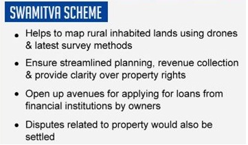
Lack of accurate land records are felt most acutely in times of crisis. Earlier the cyclone Amphan has devastated vast expanses of coastal Odisha and West Bengal, and left millions homeless. Any relief efforts aimed at helping people rebuild their homes would benefit hugely from land records that identify who lived where, and the boundaries and extent of their land. In the absence of these, there is the danger of the weakest sections losing out on the little they had, with no ability to claim compensation from the government.
Land records also play an important role in the financial resilience of Gram Panchayats. Gram Panchayats that are able to generate their own revenues will be able to invest in the needs of their local communities. Although the Gram Panchayats have a poor track record of generating revenues, especially through property tax. The 2018 Economic Survey estimated only 19% of the potential property tax was being collected by Gram Panchayats. One possible reason for low collection would be the lack of data about the properties where are they located, are they residential or commercial, what should be the appropriate tax value, and who should be taxed.
As the state and central governments gear up to implement this scheme, it will be important to ensure the programme includes four key things:
Engage the community from the start
By involving the community, it is possible to create greater acceptance of the process and reduce potential for disputes. When the land boundaries are drawn by the people themselves, there is a high level of transparency and neighbours act as a check and balance, while building consensus on boundaries.
This was witnessed in drone mapping pilots in Maharashtra where the survey department asked people to mark their own boundaries, in a bottom-up approach. In a similar exercise under Odisha’s Jaaga Mission, slum residents were involved in the boundary demarcation of their communities, that also resulted in wider acceptance of the government’s efforts to create digital maps of the slums and a low incidence of disputes.
Protect the most vulnerable people
Land often has deep roots in social power structures, including caste and gender biases. Dalits, women, tenant farmers and tribal communities are often excluded from accessing land, even though they may legitimately have a claim. It would be important to build safeguards in the implementation process to ensure legitimate claims of the most vulnerable people are not crowded out by louder, or powerful voices.
Awareness drives to familiarize people with digital land records, method to interpret and access them, also need to be built into the program to avoid information asymmetry and ensure access across user groups.
Establishment of a Grievance Redressal System
Even with the best of intentions, it is possible that the process will create grievances for some people. Drawing learnings from Odisha’s Kalia and Mo Sarkaar programmes, a grievance redressal system that effectively addresses people’s concerns in a transparent and fair manner, will go a long way in smooth implementation of the program.
Enable markets to work
It would be simplistic to expect that updated property records alone will make credit flow into rural areas. Credit needs marketable collateral, so it would be important to ensure there is a functional market for the underlying collateral land. This would require states to simplify the legislative and regulatory procedures to build consumer confidence and encourage transactions in these areas.
Conclusion
Modernising land records is one of the foundational steps towards mending and reimagining broken institutional arrangements, which are pivotal in today’s circumstances. The announcement of this scheme has signaled political will at the Centre to create reliable land records, which has been long overdue. With determination the state and central government will follow through on the actual implementation, which will go a long way towards building financial strength and independence of the local self-governance institutions, the Gram Panchayats.
Connecting the Article
Question for Prelims
With reference to the Svamitva scheme, consider the following statements:
1. It aims to create a geospatial database of all rural properties.
2. It launched by the Ministry of Panchayati Raj.
Which of the statements given above is/are correct ?
(a) 1 only
(b) 2 only
(c) Both 1 and 2
(d) Neither 1 nor 2
Question for Mains
Among several challenges for rural growth, a verified land ownership records is the most neglected one. Do you agree ? What are other challenges for rural development ? Discuss.


Our support team will be happy to assist you!

 Contact Us
  New Batch : 9555124124/ 7428085757
  Tech Support : 9555124124/ 7428085757