Prelims: (Geography + CA)
Mains: (GS 1 – Physical Geography; GS 3 – Infrastructure, Energy Security, Disaster Management, Environment) |
Why in News ?
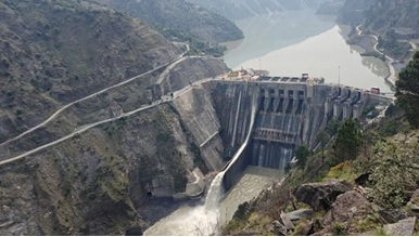
The Expert Appraisal Committee (EAC) of the Ministry of Environment, Forest and Climate Change (MoEF&CC) has recommended environmental clearance for the Dulhasti Stage-II hydropower project on the Chenab River in Jammu & Kashmir.
Background & Context
Hydropower projects in the Chenab basin are strategically significant for India due to their role in energy security, regional development, and utilisation of permissible rights under the Indus Waters Treaty (IWT), 1960.
In recent years, heightened geopolitical tensions and security concerns have accelerated India’s focus on maximising run-of-the-river hydropower potential in Jammu & Kashmir while remaining within treaty provisions. Dulhasti Stage-II represents a continuation of this approach by leveraging existing infrastructure to minimise environmental and social costs.
What is the Dulhasti Stage-II Hydropower Project ?
Location & Capacity
- 260 MW (2 × 130 MW) underground powerhouse
- Located on the Chenab River
- Kishtwar District, Jammu & Kashmir
Project Design
- A Run-of-the-River (ROR) hydropower project
- Utilises existing infrastructure of Dulhasti Stage-I
- Draws water from the Marusudar River (Chenab tributary) via the Pakal Dul Hydroelectric Project into the Dulhasti reservoir
Dulhasti Stage-I
- 390 MW ROR project
- Commissioned in 2007
- Forms the backbone infrastructure for Stage-II
Pakal Dul Hydroelectric Project Linkage
- 1,000 MW ROR hydropower project
- Located on the Marusudar River
- Features a 167-metre concrete-face rockfill dam
- Tallest dam in the Indian part of the Indus River system
- Acts as a feeder project for Dulhasti Stage-II
What is a Run-of-the-River (ROR) Project ?
- Generates electricity using the natural flow and elevation gradient of a river
- Does not involve large storage reservoirs
- Lower displacement and submergence compared to storage dams
- Considered relatively eco-friendly, though not impact-free
Strategic Significance of Dulhasti Stage-II
Energy Security
- Adds 260 MW to India’s hydropower capacity
- Supports renewable energy targets and grid stability
Indus Waters Treaty Context
- Project gained momentum after the suspension of routine engagement under IWT following the Pahalgam terror attack
- Strengthens India’s utilisation of permissible hydropower rights on western rivers
Chenab Basin Cascade Development
Dulhasti Stage-II adds to an extensive hydropower cascade including:
Operational Projects
- Dulhasti-I – 390 MW (Kishtwar)
- Baglihar – 890 MW (Ramban)
- Salal – Reasi
Under-Construction Projects
- Ratle – 850 MW
- Kiru – 624 MW
- Kwar – 540 MW
This cascade enhances cumulative power generation while optimising river flow usage.
Expert Appraisal Committee (EAC) – MoEF&CC
About
- A sector-specific, multi-disciplinary committee constituted under the EIA Notification, 2006
Primary Role
- Screens, scopes, and appraises projects requiring environmental clearance
- Provides recommendations to MoEF&CC
Structure
- Nine EACs at the central level
- Covers sectors such as:
- River Valley & Hydroelectric Projects
- Thermal & Coal Mining
- Nuclear
- Strategic & Defence Projects
Composition & Functioning
- Up to 15 subject-matter experts
- Reconstituted every three years
- Operates on consensus and collective responsibility
- Final decision rests with MoEF&CC
Indus Waters Treaty (1960)
Overview
- Bilateral treaty between India and Pakistan
- Brokered by the World Bank
- Governs the Indus River system and its tributaries
Water Allocation
- Eastern Rivers (Ravi, Beas, Sutlej): India
- Western Rivers (Indus, Jhelum, Chenab): Pakistan
- India allowed limited, non-consumptive use on western rivers for hydropower and domestic needs
Institutional Mechanism
- Permanent Indus Commission (PIC) with annual meetings
- Three-tier dispute resolution:
- PIC discussions
- Neutral Expert
- Court of Arbitration
Chenab River: Geographical Overview
Origin
- Rises as Chandrabhaga near Baralacha Pass, Himachal Pradesh
- Formed by confluence of Chandra and Bhaga rivers
Major Tributaries
- Marusudar (largest)
- Miyar Nalla
- Bhut Nalla
- Kalnai
- Ans
- Tawi
- Neeru
Course
- Flows through Kishtwar, Doda, Ramban, Reasi
- Enters Pakistan’s Punjab plains
- Joins the Sutlej → Panjnad → Indus
Environmental Concerns and Way Forward
Key Concerns
- Cumulative ecological impact of multiple projects
- Alteration of riverine ecology and sediment flow
- Disaster vulnerability in seismic Himalayan zones
Way Forward
- Basin-level cumulative impact assessments
- Strict compliance with EIA conditions
- Disaster-resilient design and monitoring
- Balancing strategic interests with ecological sustainability


 Contact Us
  New Batch : 9555124124/ 7428085757
  Tech Support : 9555124124/ 7428085757