- UPSC Exam
- State PCS
- One Day Exam
- Current Affairs
- PT Quiz
- Downlaods
- About Coaching
- Blog
- Videos
| Prelims: (Geography + CA) Mains: (GS 1 – Physical Geography; GS 3 – Disaster Management, Infrastructure Security) |
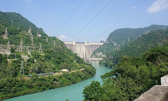
Amid rising incidents of monsoon-induced landslides in the surrounding hillocks, the Geological Survey of India is likely to undertake a comprehensive geological study of areas around the Bhakra Dam to assess slope stability and long-term structural safety.
India’s Himalayan and sub-Himalayan regions are:
Large dam infrastructure in such fragile zones faces multiple risks:
The Bhakra Dam region, located in the Shivalik foothills, has witnessed increasing rainfall variability and extreme weather events, raising concerns about:
Given the dam’s strategic importance for irrigation and power generation, scientific monitoring is critical.
1. Gobind Sagar Reservoir
2. Nangal Dam
The Bhakra Dam plays a crucial role in:
1. Irrigation
Supports agricultural productivity in:
2. Hydroelectric Power Generation
3. Flood Control
1. Landslides During Monsoon
2. Reservoir-Induced Seismicity
Large reservoirs can sometimes:
3. Infrastructure Vulnerability
Unstable hillocks may:
1. Strengthening Dam Safety Mechanisms
A detailed geological assessment can:
2. Enhancing Disaster Preparedness
Scientific data will help in:
3. Protecting Strategic Infrastructure
Bhakra Dam is vital for:
Ensuring geological stability safeguards these national interests.
4. Climate Change Adaptation
With increasing frequency of extreme rainfall events, geological reassessment aligns with:
5. Sustainable River Basin Management
Understanding slope dynamics helps in:
India has strengthened dam safety frameworks through:
The study around Bhakra Dam reflects proactive infrastructure governance rather than reactive crisis management.
FAQs1. Where is the Bhakra Dam located? It is built across the Sutlej River in Bilaspur district of Himachal Pradesh near the Punjab border. 2. Why is a geological study being conducted around Bhakra Dam? Due to rising landslides during the monsoon season, authorities aim to assess slope stability and structural safety. 3. Which body operates and maintains the Bhakra Dam? The Bhakra Beas Management Board (BBMB) manages its operation and maintenance. 4. What is the importance of Gobind Sagar Reservoir? It is one of India’s largest reservoirs and supports irrigation, power generation, and flood control. 5. Why is Bhakra Dam strategically significant for India? It ensures irrigation for major agricultural states, provides renewable energy, regulates floods, and supports regional water security. |


Our support team will be happy to assist you!

 Contact Us
  New Batch : 9555124124/ 7428085757
  Tech Support : 9555124124/ 7428085757