- UPSC Exam
- State PCS
- One Day Exam
- Current Affairs
- PT Quiz
- Downlaods
- About Coaching
- Blog
- Videos
|
Syllabus: Prelims GS Paper I : Current Events of National and International Importance. Mains GS Paper II : India and its Neighborhood- Relations. |
Context
A ray of hope glimmers amidst tension between India and Nepal.
Background
In May tension between India and Nepal escalated, months later a hope of rebuilding of friendly relations has emerged. Nepalese Prime Minister greeted Indian PM and the people of India on the country's 74th Independence Day. Nepal's ambassador to India claimed that the ties between the two nations are close and friendly and that both sides can sit together in proper times and solve any problem. The immediate provocation is the long-standing territorial issue surrounding Kalapani, a patch of land near the India-Nepal border, close to the Lipulekh Pass on the India-China border, which is one of the approved points for border trade and the route for the Kailash-Mansarovar yatra in Tibet.
Cause of Tussle
India inherited the boundary with Nepal, established between Nepal and the East India Company in the Treaty of Sugauli in 1816. Kali river constituted the boundary, and the territory to its east was Nepal. The dispute relates to the origin of Kali. There is a confluence of different streams coming from north-east from Kalapani and north-west from Limpiyadhura. The early British survey maps identified the north-west stream, Kuti Yangti, from Limpiyadhura as the origin, but after 1857 changed the alignment to Lipu Gad, and in 1879 to Pankha Gad, the north-east streams, thus defining the origin as just below Kalapani. Nepal accepted the change and India inherited this boundary in 1947.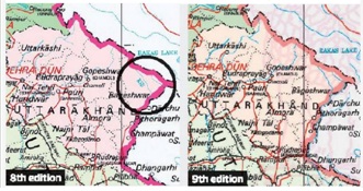
The Maoist revolution in China in 1949, followed by the takeover of Tibet, created deep misgivings in Nepal, and India was ‘invited’ to set up 18 border posts along the Nepal-Tibet border. The westernmost post was at Tinkar Pass, about 6 km further east of Lipulekh. In 1953, India and China identified Lipulekh Pass for both pilgrims and border trade. After the 1962 war, pilgrimage through Lipulekh resumed in 1981, and border trade, in 1991.
In 1961, King Mahendra visited Beijing to sign the China-Nepal Boundary Treaty that defines the zero point in the west, just north of Tinkar Pass. By 1969, India had withdrawn its border posts from Nepali territory. The base camp for Lipulekh remained at Kalapani, less than 10 km west of Lipulekh. In their respective maps, both countries showed Kalapani as the origin of Kali river and as part of their territory. After 1979, the Indo-Tibetan Border Police manned the Lipulekh Pass.
After the 1996 Treaty of Mahakali (Kali river is also called Mahakali/Sarada further downstream) that envisaged the Pancheshwar multipurpose hydel project, the issue of the origin of Kali river was first raised in 1997. The matter was referred to the Joint Technical Level Boundary Committee that had been set up in 1981 to re-identify and replace the old and damaged boundary pillars along the India-Nepal border. The Committee clarified 98% of the boundary, leaving behind the unresolved issues of Kalapani and Susta (in the Terai) when it was dissolved in 2008. It was subsequently agreed that the matter would be discussed at the Foreign Secretary level. Meanwhile, the project to convert the 80-km track from Ghatibagar to Lipulekh into a hardtop road began in 2009 without any objections from Nepal.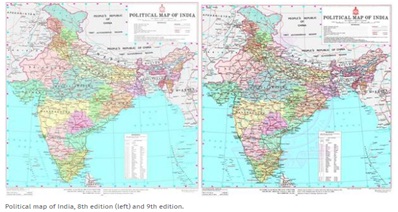
The Survey of India issued a new political map (eighth edition) on November 2, 2019, to reflect the change in the status of Jammu and Kashmir as two Union Territories. Nepal registered a protest though the map in no way had changed the boundary between India and Nepal. However, the delineation remained identical but the name Kali river had been deleted. Nepal invoking Foreign Secretary-level talks to resolve issues but India didn't take it seriously.
Nepal’s New Map
A new map of Nepal based on the older British survey reflecting the Kali river originating from Limpiyadhura in the north-west of Garbyang. The new alignment adds 335 sq km to Nepali territory, territory that has never been reflected in a Nepali map for nearly 170 years.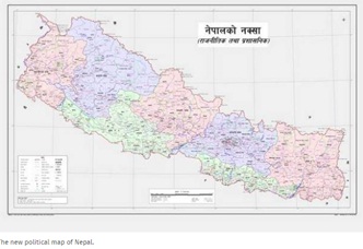
Conclusion
The urgent need today is to pause the rhetoric on territorial nationalism and lay the groundwork for a quiet dialogue where both sides need to display sensitivity as they explore the terms of a reset of the “special relationship”. A normal relationship where India can be a generous partner will be a better foundation for “neighbourhood first” in the 21st century.
Connecting the Article
Question for Prelims
Treaty of Mahakali was signed to complete the
(a) Pancheshwar hydel project.
(b) Seli hydel project.
(c) Miyar hydel project.
(d) None of these
Question for Mains
‘India and Nepal share deep social, cultural, strategic, political, and economic ties that have been forged over many centuries.’ Comment.


Our support team will be happy to assist you!

 Contact Us
  New Batch : 9555124124/ 7428085757
  Tech Support : 9555124124/ 7428085757