(Prelims: Current Events of National and International Importance, Geography of India and the World)
(Mains, General Studies Paper 2: India and Its Neighborhoods - Relations, Impact of Policies and Politics of Developed and Developing Countries on India's Interests) |
Context
Indian Defense Minister Rajnath Singh warned Pakistan about its recent military buildup at Sir Creek, revealing its true intentions. On this occasion, the Arms Puja (weapon worship) of the advanced L-70 air defense gun was performed at the Bhuj military base in the presence of Army Chief General Upendra Dwivedi and other senior officers. The L-70 played a key role in targeting Pakistani drones and weapons during Operation Sindoor.
About the Sir Creek Dispute
- The roots of the Sir Creek dispute date back to around 1908, before independence, when disagreements arose between the rulers of Kutch and Sindh over the division of the two princely states.
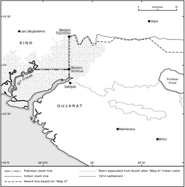
- It was resolved by the Bombay State Government in 1914 on the basis of Map B-44 and later B-74. After this, no significant developments occurred for approximately 40-50 years, and the issue resurfaced in the 1960s.
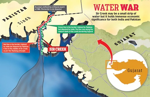
- Sir Creek is a tidal channel sixty miles long, located in the marshy region of the Rann of Kutch. It lies on the border between Gujarat and Pakistan's Sindh province.
- Following the armed conflicts of 1965, Pakistan claimed half of the Rann of Kutch near the 24th parallel, while India maintains its border primarily along the northern edge of the Rann.
- The matter went to the International Tribunal, which in 1968 upheld India's claim to 90% of the Rann and awarded some portions to Pakistan.
Rounds and History of Talks
- India and Pakistan have held six rounds of discussions on this dispute, but no concrete progress has been made. India claims that the border between the two countries runs through the creek, while Pakistan considers it to be on the creek's eastern bank.
- The demarcation of the India-Pakistan maritime boundary is linked to the land border, and Pakistan wants the boundary in the creek to be demarcated first to establish a basis for a maritime boundary.
- The first round was held in Islamabad on June 2, 1989, followed by the second and third rounds in 1990 and 1991, which also ended inconclusively. The fourth round of talks was held in Rawalpindi in 1991, but technical difficulties arose regarding the demarcation of the maritime boundary. The fifth round of talks was held in New Delhi in 1992, which also included technical experts from the Indian Navy. After the fifth round, the talks were suspended for some time.
- The Sir Creek Working Group met in New Delhi on November 8, 1998. The Indian side proposed four stages of boundary demarcation: allocation, delimitation, demarcation, and administration.
- Allocation: This is the decision on the basis of which a settlement or resolution of the dispute will be decided.
- Delimitation: This involves setting general standards for the location and features of the boundary line. Illustrative maps may be provided, but this is not mandatory.
- Demarcation: This process involves accurately applying the established delimitation standards to the actual situation.
- Administration: This involves the need to manage the demarcated boundary and ensure administrative control over it.


 Contact Us
  New Batch : 9555124124/ 7428085757
  Tech Support : 9555124124/ 7428085757