- UPSC Exam
- State PCS
- One Day Exam
- Current Affairs
- PT Quiz
- Downlaods
- About Coaching
- Blog
- Videos
Recently, during the Southern Hemisphere summer (January 2026), an unusual phytoplankton bloom was observed in the ocean around the Chatham Islands. The bloom was so extensive that it was clearly visible from space through the VIIRS sensor of the NOAA-20 satellite. Swirling green and blue patterns appeared on the sea surface, indicating intense biological activity.
Phytoplankton are microscopic, photosynthetic organisms and form the foundation of the marine food chain. A sudden increase in their population affects marine ecosystems, fishery resources, and even the global carbon cycle.
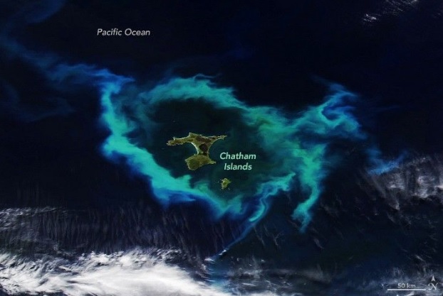
The Chatham Islands are an archipelago located in the South Pacific Ocean. They represent the easternmost territory of New Zealand and lie about 800 km east of the South Island. The group consists of around 10 islands, but only two have permanent settlements:
The Chatham Islands are located on a submerged oceanic plateau known as the Chatham Rise.
The mixing of these currents increases the availability of nutrients in seawater. During summer, longer daylight hours and stronger sunlight enhance the rate of photosynthesis, leading to rapid phytoplankton growth.
1. Base of the Marine Food Chain
Phytoplankton are primary producers, supporting the entire marine ecosystem.
2. Rich Fishery Resources
The region is a highly productive fishing ground with major species such as:
These contribute significantly to the local economy.
3. High Biodiversity
The area is an important habitat for marine mammals.
4. Risk of Whale Stranding


Our support team will be happy to assist you!

 Contact Us
  New Batch : 9555124124/ 7428085757
  Tech Support : 9555124124/ 7428085757