Prelims: (Geography + CA)
Mains: (GS 1 – Geography, GS 3 – Disaster Management) |
Why in the News ?
Cyclone Ditwah, currently moving over the southwest Bay of Bengal near the Sri Lanka coast, has caused at least 56 deaths in Sri Lanka. The system is now advancing towards Tamil Nadu and Andhra Pradesh, prompting heavy rainfall alerts across southern India.
A remnant depression of cyclone ‘Senyar’ over the Strait of Malacca is also contributing to enhanced rainfall activity.
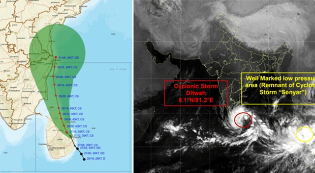
About Cyclone Ditwah
- Originated from a deep depression near Sri Lanka’s coastline.
- Classified as a cyclonic storm by IMD, with no forecast upgrade to severe cyclone so far.
- Expected to track towards north Tamil Nadu, Puducherry, and south Andhra Pradesh.
- Causing widespread rainfall and strong winds across Sri Lanka, Tamil Nadu, Andhra Pradesh, and coastal regions of the Bay of Bengal.
Cyclone Name Origin
- The name “Ditwah” was suggested by Yemen.
- Likely inspired by Detwah Lagoon on Yemen’s Socotra Island.
IMD Weather Forecast & Alerts
Rainfall Forecast (Nov 29 – Dec 1)
- Rayalaseema & South Coastal Andhra Pradesh: Very heavy to extremely heavy rainfall.
- Tamil Nadu (North Coastal districts): Widespread moderate to heavy rainfall, isolated extremely heavy falls.
- Puducherry & Karaikal: Heavy rainfall with orange alert.
Wind Speeds
- Near core: 60–80 kmph, gusting to 90 kmph
- Outer bands: 35–45 kmph, gusting to 55 kmph
- Similar wind conditions expected near Kerala, Lakshadweep & Maldives on the Arabian Sea side.
Fishermen Advisory
- Fishermen warned against venturing into large parts of the Bay of Bengal for the next 5 days.
State-wise Impact & Preparedness
Tamil Nadu
- Red Alert for:
- Thanjavur
- Tiruvarur
- Nagapattinam
- Mayiladuthurai
- Possible rainfall exceeding 20 cm in 24 hours.
Orange Alert for Chennai, Tiruvallur, Chengalpattu, Kancheepuram, Ranipet.
- CM M.K. Stalin chaired a high-level meeting with the Disaster Management Authority.
- Departments instructed to coordinate rescue, relief and emergency response.
Rainfall Status
- Scattered rainfall in the last 24 hours.
- Northeast monsoon so far: ~35 cm, slightly above normal.
- Chennai remains 31% below normal for the season.
Andhra Pradesh
- System expected to approach North Tamil Nadu–Puducherry–South Andhra between Nov 29 evening and Nov 30 morning.
- Heavy rain and strong winds forecast for:
- Chittoor
- Tirupati
- Nellore
- Prakasam
- YSR Kadapa
- Annamayya
- Sri Sathya Sai district
The State Disaster Management Authority confirms strengthening of the depression into a cyclone moving north-northwest.
Impact in Sri Lanka
- At least 56 persons reported dead due to flooding, landslides, and storm-related incidents.
- Emergency measures underway with evacuation of vulnerable communities.
Puducherry Alerts
- Orange alert from Nov 28 to Dec 1.
- Administration advises residents to stay indoors, avoid trees, lamp posts, and old structures.
- Preparedness measures include relief camps, drainage clearance, and coastal surveillance.
Geographical & Climatic Context
- Ditwah formed during the Northeast Monsoon, which drives rainfall across Tamil Nadu and coastal Andhra Pradesh.
- Warm sea surface temperatures in the Bay of Bengal accelerate cyclogenesis.
- Interaction with remnants of Cyclone Senyar added moisture and instability.
Expected Outcomes & Concerns
- Potential for urban flooding, waterlogging, landslides (in hilly regions).
- Disruptions in power supply, transportation, and fishing activities.
- Possible damage to coastal infrastructure and crops.
- Need for continuous monitoring as landfall trajectory can shift.
FAQs
1. What is the intensity of Cyclone Ditwah ?
It is classified as a cyclonic storm, with no prediction of escalation to a severe cyclone.
2. Which states are on high alert ?
Tamil Nadu, Andhra Pradesh, and Puducherry.
3. Why is Sri Lanka heavily affected ?
The system developed very close to the Sri Lankan coast, bringing torrential rain and triggering floods/landslides.
4. What are the expected wind speeds ?
Core winds: 60–80 kmph, gusting to 90 kmph.
5. Why are fishermen warned ?
High waves, rough seas, and strong winds in the Bay of Bengal make conditions unsafe.
|


 Contact Us
  New Batch : 9555124124/ 7428085757
  Tech Support : 9555124124/ 7428085757