- UPSC Exam
- State PCS
- One Day Exam
- Current Affairs
- PT Quiz
- Downlaods
- About Coaching
- Blog
- Videos
| Syllabus: Prelims GS Paper I : Indian and World Geography-Physical, Social, Economic Geography of India and the World. Mains GS Paper III : Disaster and disaster management. |
Context
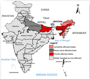
Impact of heavy rainfall in the northeast India and grim situation caused by floods in Assam and Bihar.
Background
Amid rising COVID-19 cases, heavy rainfall with the start of the 2020 Monsoon season triggered severe flooding in east and northeast India. Flooding affected Assam state since 8 July but worsened considerably since 12 July, affecting more than 25 lakh people in 30 of 33 districts (as of 21 July). At least 83,000 people are sheltered in approximately 500 government-established relief camps and centre, with more people displaced to makeshift shelters. At least 87 people have lost their lives while the risk of more flooding and landslides persists. Urgent relief, rescue, shelter and food are needed.
Aggravating Factors
Ongoing monsoon season and topography:
The southwest monsoon season typically lasts from June to September, which provides most of India’s water needs and causes widespread flooding and landslides every year. This year floods are hitting Bihar and Assam States particularly hard.
Rivers:
Assam and Bihar with their vast network of rivers are prone to natural disasters like flood and erosion which has a negative impact on overall development of these States. The Brahmaputra and Barak rivers in Assam and Kosi river in Bihar with their number of tributaries feeding them, cause the flood devastation in the monsoon period each year.
Agriculture and livelihoods in Assam
It is estimated that more than 80% of Assam’s population being dependent on agriculture and more than 50% are directly involved in agricultural activities. Around 55% of the total geographical area of Assam is used for agricultural production; many fields are located alongside the Brahmaputra river and its various streams.
Increasing population growth, deforestation, periodical flooding, embankment based flood control and the Jhum cultivation practice (slash and burn agriculture practiced by locals) constitute the main reason of wide-spread soil erosion and increased silting which increases the impact of floods every year. These floods have not only affected the agriculture but normal life also.
Earthquakes and Landslides
Assam and some other parts of the northeastern region are prone to frequent earthquakes, which causes landslides. The landslides and earthquakes send in a lot of debris in the rivers, causing the river bed to rise.
Bank Erosion
Assam has also faced bank erosion around the Brahmaputra and Barak rivers as well as their tributaries. It is estimated that annually nearly 8000 hectares land is lost to erosion. Bank erosion has also affected the width of the Brahmaputra river, which has increased up to 15 km. The damage cost due to bank erosion is estimated to be of several hundred crores every year.
Dams and Embankments
Among the man-made reasons, the key cause of floods in Assam region is releasing of water from dams situated uphill. Unregulated release of water floods the Assam plains, leaving thousands of people homeless every year. Embankments increased silting which diminishes the water-carrying capacity of the river catchment and water outflows in form of floods.
Encroachment
Encroachment in forest lands and wetlands is another main reason that causes flood in these States.
Non-Implementation of Projects
Looking at the grim situation, the Centre had sanctioned a project of Brahmaputra dredging; however, sources said that the project is yet to begin. The project involves dredging and de-silting a stretch of 891 km of Brahmaputra from Sadiya in the north to Dhubri in the south of the state but it is still in the planning stage.
Government Measures to manage the flood-disaster
After the unprecedented floods in the country in 1954, the Govt. of India announced a National Policy on Floods comprising three phases viz.-
The flood control activities in Assam started mainly after the announcement of National Water Policy. Subsequently, "outlined plan for flood control in Assam" along with various comprehensive plans were prepared and the priority areas, which need immediate and urgent attention were identified.
In 1980, Central Government set up a special body Brahmaputra Board to look in to the important measures to curb the flood in Brahmaputra and Barak Valley
Till date, the Water Resources Department has taken up works primarily for the general development of the rural sector and for the protection of major townships in both the Brahmaputra and Barak valley. Schemes have also been taken up to relieve the drainage congestion in the cities to control urban floods.
|
BRAHMAPUTRA BOARD The Brahmaputra Board was set up under the then Ministry of Irrigation by the Government of India under an Act of Parliament called ‘The Brahmaputra Board Act, 1980 (46 of 1980)’ for the planning and integrated implementation of measures for the control of floods and bank erosion in the Brahmaputra Valley and for matters connected therewith. The Board office started functioning with Headquarters at Guwahati with effect from 11th January 1982. The jurisdiction of the Board covers entire Brahmaputra and Barak Valley, spreading in all the States of the North Eastern Region including Sikkim and part of West Bengal falling under Brahmaputra Basin. |
Way Forward:
Although it is not possible to flood-proof all of Assam, several measures should be undertaken for a long-term solution. Increasing the water holding capacity of Brahmaputra and its tributaries by dredging will be an effective solution to eliminate the havoc of flood from the State. Moreover, the rejuvenation of wetlands, afforestation, decentralization of weather forecast, construction of more micro and scientific reservoirs and dams, establishment of river valley projects, etc. may reduce the problem considerably in the long run. It will decrease the rate of disaster by almost 70%. Besides, dredging will also contribute to the development of water highway in the Brahmaputra, which will be a good option to develop our economy.
Connecting the Dots
Question for Prelims
Majuli is one of the largest riverine island in the world, located on which of the following river?
(a) Brahmaputra
(b) Lohit
(c) Ganga
(d) Barak
Question for Mains
Every year, floods in the northeast India badly impact the life of people despite several efforts. Which of the possible measures can be taken to manage the floods in the northeastern India?


Our support team will be happy to assist you!

 Contact Us
  New Batch : 9555124124/ 7428085757
  Tech Support : 9555124124/ 7428085757