Prelims: Geography | Environment | Glaciers | Disaster Management
Mains: GS-I – Physical Geography | GS-III – Environment & Disaster Management |
Why in News?
An Early Warning System (EWS) is scheduled to be installed at Ghepan Lake in September 2026. The system is expected to continuously monitor conditions around the lake and provide timely alerts in case indicators point towards a possible GLOF.
About Ghepan Glacial Lake
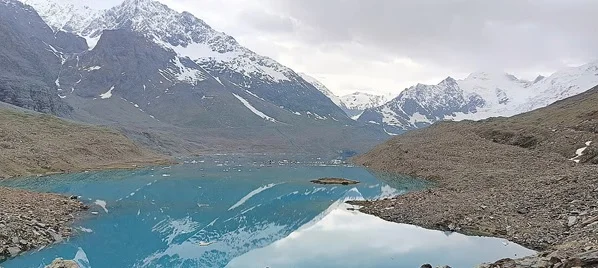
- Ghepan Glacial Lake, also known as Ghepang Ghat Glacial Lake, is a high-altitude glacial lake located in the Lahaul region of Lahaul-Spiti district, Himachal Pradesh.
- The lake lies at an elevation of approximately 4,068–4,070 metres above mean sea level in the upper reaches of the Chandra sub-basin of the Indus river system.
- It is located above Sissu village, one of the important settlements in the Lahaul Valley.
- The lake is associated with Ghepan or Raja Ghepan, the revered protector deity of the Lahaul Valley. This gives the lake significance not only from a geographical and environmental perspective but also from the point of view of local culture.
- The turquoise-coloured lake, surrounded by glaciers and high Himalayan terrain, has also emerged as a trekking destination.
Why is Ghepan Lake Becoming a Concern?
- The major concern is the rapid expansion of the glacial lake as the glacier retreats.
- An official Himachal Pradesh disaster-management assessment using satellite imagery found that the lake's water-spread area increased from approximately 36.49 hectares in 1989 to 101.30 hectares in 2022.
- This represents an increase of around 178%.
- Such rapid expansion is important because a larger lake can store a much greater volume of water behind its natural moraine barrier.
- As glaciers retreat under warming conditions, meltwater can accumulate in depressions created near the glacier. Many such lakes are held back by relatively loose accumulations of rocks, sediments and glacial debris known as moraines.
Unlike engineered dams, moraine barriers can be unstable and vulnerable to sudden failure.
How Can a GLOF Occur at Ghepan Lake?
- Several mechanisms can potentially destabilise a high-altitude glacial lake.
- An ice avalanche, rockfall or landslide entering the lake can generate a large displacement wave. This wave may overtop the moraine barrier holding the lake.
- Continuous glacier melting can also increase the volume of water stored in the lake and place additional pressure on its natural barrier.
- Extreme rainfall, slope instability, earthquakes and degradation of ice contained within moraine structures can further increase the possibility of failure.
- In the case of Ghepan Lake, the surrounding slopes are susceptible to avalanches and mass movements. This makes monitoring particularly important.
Why Could a Ghepan GLOF Be Dangerous?
- The geography downstream of Ghepan Lake increases the potential consequences of a sudden outburst.
- Sissu village lies roughly 11 km downstream and around 1,000 metres below the lake.
- The Sissu Nalla descends through steep Himalayan terrain before joining the Chandra River.
- According to risk assessments, the steep gradient and narrow channel can contribute to greater flow depths and high-energy flood conditions during a possible GLOF.
- Therefore, the concern is not simply the amount of water stored in the lake. The combination of high elevation, steep relief, narrow valleys and downstream settlements can amplify the destructive potential of an outburst.
Lessons from the Recent Nepal Himalayan Disaster
- The recent catastrophic glacier-related flood affecting the Nepal-China Himalayan region has again demonstrated how quickly a cryospheric hazard can turn into a cascading disaster.
- A glacier or ice-rock collapse can trigger debris movement, temporarily block rivers, create unstable lakes and eventually generate destructive downstream flooding.
- Such events can damage roads, bridges, hydropower projects, electricity networks and communication infrastructure while simultaneously making rescue operations more difficult.
- The important lesson for India is therefore to shift disaster management from post-disaster response to pre-disaster risk reduction.
- For vulnerable Himalayan lakes such as Ghepan, continuous monitoring and early warning are essential.
Early Warning System at Ghepan Lake
- The planned Early Warning System represents an important move towards technology-based disaster preparedness.
- Instead of depending entirely on occasional field visits, an EWS can help authorities continuously assess changing conditions and issue alerts when predefined danger indicators are detected.
Monitoring of vulnerable glacial lakes can involve:
- Satellite Remote Sensing: To observe changes in lake area and surrounding glaciers.
- Automatic Weather Stations: To monitor temperature, precipitation and other meteorological variables.
- Water-Level Sensors: To identify abnormal changes in lake levels.
- Cameras: To provide visual monitoring of the lake and surrounding slopes.
- Communication Systems: To transmit warnings quickly to administrative authorities and downstream communities.
The ultimate objective should be to connect scientific monitoring with last-mile warning and evacuation systems.
Why the Western Himalayas are Vulnerable
- The Western Himalayan region combines several physical conditions that increase disaster vulnerability.
- The Himalayas are geologically young and tectonically active mountains characterised by steep slopes and fragile geological formations.
- Climate change adds another layer of risk by influencing glaciers, snow cover, permafrost and extreme precipitation.
- At the same time, roads, tunnels, hydropower projects, tourism facilities and settlements are increasingly concentrated within narrow river valleys.
- Consequently, relatively localised high-altitude hazards can produce much wider downstream consequences.
- This creates the possibility of a cascading Himalayan disaster, where one natural event triggers several interconnected failures.
Challenges in Managing GLOF Risk
- The first major challenge is accessibility. Many vulnerable lakes are located thousands of metres above sea level in remote terrain, making installation and maintenance of instruments difficult.
- Second, glacial environments are extremely dynamic. Lake size, glacier movement, moraine stability and surrounding slopes can change over relatively short periods.
- Third, satellite monitoring cannot always provide continuous real-time information because of cloud cover, revisit intervals and other limitations.
- Fourth, warning systems must ultimately reach downstream residents quickly. A technologically sophisticated monitoring system is of little use if the last-mile communication network fails.
- Finally, Himalayan river systems frequently cross political boundaries. This makes transboundary hydrological and cryospheric data sharing increasingly important.
Way Forward
- India should move towards a Himalayan Glacial Risk Management Framework rather than treating individual GLOFs as isolated disasters.
- High-risk glacial lakes should be continuously classified and prioritised according to their probability of failure and potential downstream exposure.
- Remote-sensing observations should be supplemented by field-based measurements wherever feasible.
Prelims MCQ
Q. Consider the following statements regarding Ghepan Glacial Lake:
- It is located in the Lahaul-Spiti district of Himachal Pradesh.
- Its drainage ultimately forms part of the Indus River system.
- Sissu Nalla emerging from the lake joins the Chandra River.
Which of the statements given above are correct?
(a) 1 and 2 only
(b) 2 and 3 only
(c) 1 and 3 only
(d) 1, 2 and 3
Mains Question
“The expansion of glacial lakes is transforming climate change into a major disaster-management challenge in the Indian Himalayan Region.” Critically examine with reference to Ghepan Glacial Lake.
|




 Contact Us
  New Batch : 9555124124/ 7428085757
  Tech Support : 9555124124/ 7428085757