| (GS Paper 3 — Environment & Economy) |
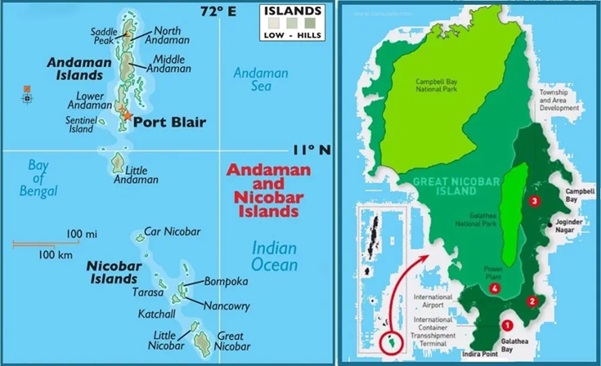
- The Great Nicobar Island is India’s southernmost and largest island, forming an integral part of the Andaman & Nicobar Islands.
- It holds immense strategic and ecological importance for India’s maritime boundaries.
- Recently, the proposed Great Nicobar Island Development Project (GNI Project) has triggered widespread debate concerning environmental sustainability, national security, and tribal rights.
Geographical Overview
|
Aspect
|
Details
|
|
Location
|
Southern tip of the Bay of Bengal, ~180 km from Sumatra (Indonesia)
|
|
Area
|
910 sq. km
|
|
Coordinates
|
6°45′ N – 7°15′ N and 93°38′ E – 93°56′ E
|
|
Notable Point
|
Indira Point — India’s southernmost landmass (remained intact even after the 2004 Tsunami)
|
|
Administrative Centre
|
Campbell Bay
|
Geographical and Ecological Features
- Declared a UNESCO Biosphere Reserve in 2013.
- Covered with dense tropical rainforests, rich in biodiversity.
- Major species found:
- Nicobar Megapode (Nicobari pigeon)
- Saltwater crocodiles and Dugongs (Sea Cow)
- Loggerhead and Green turtles
- The Great Nicobar Biosphere Reserve is divided into:
- Core Zone: 885 sq. km
- Buffer Zone: 705 sq. km
Population and Tribal Composition
|
Tribe
|
Characteristics
|
Population (Est. 2021)
|
|
Shompen
|
Semi-nomadic, hunter-gatherer, isolated from external contact
|
250
|
|
Nicobarese
|
Settled, engaged in agriculture and fishing
|
1,500
|
Strategic Importance
- Geographical Advantage:
- Located ~160 km from the Strait of Malacca, one of the world’s busiest trade routes.
- Around 40% of global oil trade passes through this region.
- Naval and Surveillance Base:
- INS Baaz, established in 2012, is India’s southernmost naval air station.
- Enhances India’s Indo-Pacific maritime surveillance capabilities.
- Serves as a countermeasure to China’s “String of Pearls” strategy.
- Blue Economy & Maritime Security:
- Integral to India’s Act East Policy and Sagarmala Vision.
- Potential to strengthen India’s presence in ASEAN and Indo-Pacific partnerships.
Great Nicobar Island Development Project (GNI Project)
- Proposed by: NITI Aayog, aligned with Vision 2036
- Estimated Cost: ₹72,000 crore
Major Components:
- International Container Transshipment Terminal (ICTT):
- Capacity: 14.2 million TEU
- Greenfield Airport:
- Dual-use (civil and defense)
- Power Plant & Smart City:
- Eco-tourism & Deep-Sea Port Hub
Objectives:
- To transform India into a global maritime trade hub.
- To reduce dependence on transshipment hubs like Singapore and Colombo.
Environmental and Social Concerns
Environmental Impact
- Possible destruction of ~130 sq. km of forest area.
- Threat to seasonal water balance and coastal ecology.
- Likely damage to turtle nesting grounds and marine ecosystems.
- Located in Seismic Zone V, prone to earthquakes and tsunamis.
Tribal Impact
- Threat to the survival and livelihood of Shompen and Nicobarese tribes.
- Influx of outsiders may lead to cultural erosion, disease spread, and displacement.
Legal Challenges
- In 2023, the National Green Tribunal (NGT) granted conditional clearance, mandating Compensatory Afforestation and a Biodiversity Impact Assessment.
- Environmentalists argue the project could trigger an ecological disaster rather than an economic boon.
Government’s Stand
- The project adheres to the principles of Sustainable Development.
- No-Go Zones to be established in tribal and ecologically sensitive areas.
- Promises of employment generation, infrastructure improvement, and national security enhancement.
- Use of Green Technology and Renewable Energy sources.
Analytical Overview
|
Dimension
|
Analysis
|
|
Geographical
|
Represents India’s southernmost frontier in the Indian Ocean.
|
|
Ecological
|
High risk to biodiversity, coral reefs, marine life, and tropical ecosystems.
|
|
Strategic
|
Crucial for India’s Indo-Pacific strategy and maritime dominance.
|
|
Economic
|
Potential to establish India as a major transshipment hub.
|
|
Social
|
A test case for balancing development and conservation — tribal rights vs. national interest.
|
Conclusion
The Great Nicobar Island is a region of immense strategic value, ecological sensitivity, and unique cultural heritage. India must strike a fine balance between development, ecology, and indigenous protection. Sustainable development here must mean growth with responsibility — safeguarding nature, culture, and national security alike.
“Great Nicobar is not just an island — it is a test of India’s maritime self-reliance and ecological wisdom.”
|
Possible UPSC Questions
- “The Great Nicobar Island Project is central to India’s maritime strategy, yet ecologically contentious.” — Discuss.
(GS Paper 3 — Environment & Economy)
- “The balance between development and conservation will determine the future of Great Nicobar Island.” — Comment.
(Essay / GS Paper 2)
- “The Andaman and Nicobar Islands form the natural anchor point of India’s Indo-Pacific policy.” — Explain.
(GS Paper 2 — International Relations)
|


 Contact Us
  New Batch : 9555124124/ 7428085757
  Tech Support : 9555124124/ 7428085757