(Preliminary Exam: Geography of India)
(Main Exam, General Studies Paper- 1: Main features of physical geography of the world, geographical features and their location-changes in the most important geographical features and flora and fauna and the effects of such changes) |
Reference
At present, a significant increase has been recorded in the length of India's coastline and the number of islands. The coastline has increased to 11,098 km., which shows an increase of about 48%.
Increase in the length of the coastline
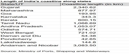
- New measurement: In the 1970s, the length of India's coastline was estimated to be 7,516 km. But after the recent accurate measurement, this length has been recorded as 11,098 km., which shows an increase of about 3,582 km (about 48%).
- Reasons: This increase is not due to the acquisition of any new land area but due to the use of more accurate modern measurement techniques.
- Better resolution data: Earlier measurements were based on data at a scale of 1:4,500,000 or smaller. Now higher resolution data of 1:250,000 is used.
- Coastlines are highly irregular and high resolution data captures their bends, curves and fine details better.
- In low resolution these details are smoothened and appear as straight lines, leading to underestimation of length.
- Use of modern technology: Earlier measurements were based on traditional and manual calculations. Now modern Geographic Information System (GIS) software is used which can measure land irregularities more accurately.
- In addition, earlier calculations did not include the coastlines of many offshore islands, which have now been added to the measurement.
|
Coastline Paradox: Philosophical paradox of measurement
- The new length of the coastline is more accurate but it is not the actual length. According to the Coastline Paradox, the length of irregular structures like coastline depends on the scale of measurement.
- More detailed measurements will always result in a longer length of the coastline. This paradox also applies to other natural structures like rivers and mountain ranges. Therefore, with technological advancement, the length of the coastline may increase further in the future. For this reason, remeasurement of the coastline has now been made mandatory every ten years.
|
Recounting of islands: Clarity of definition
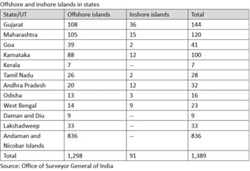
- Earlier calculation: In the year 2016, the Surveyor General of India had listed 1,382 offshore islands. However, this number was 1,334 in the calculation of state governments, Coast Guard and Indian Navy.
- New Census and Standardisation: After a data reconciliation process, a new number of 1,298 offshore islands was determined by removing ambiguities in definitions and standardising classification.
- 91 coastal islands were also listed. Thus, the total number of islands is 1,389. This does not include river islands in states like Assam and West Bengal.
- Reason for Standardisation: There are certain complexities in counting islands. For example, some places may be islands during high tide but may be connected to the mainland during low tide. Standardised definitions have been adopted to remove these ambiguities.
Administrative and Strategic Implications of the Change
Academic Importance
Since there is no actual change on land and this increase in the coastline and number of islands is mainly academic, it does not have any major international implications.
Administrative and Strategic Importance
Nevertheless, these figures provide a better understanding of the area and topography of India. These have administrative, developmental and security implications. For example:
- Coastal Zone Regulation (CRZ): New coastlines may affect the extent of CRZ in some places.
- Coastal erosion and climate change: Efforts to prevent coastal erosion and make coastlines resilient to climate change threats will be affected.
- Tourism and infrastructure: Tourism and coastal infrastructure development may also be affected by these new data.
Conclusion
- The increase in the length of India’s coastline and the number of islands is a result of modern technologies and accurate measurements. This information is important from administrative and strategic perspectives. Additional changes in these data are possible with more accurate measurements in the future. Technological advances and regular remeasurements will contribute to a better understanding and management of India’s coastal areas.
- Like India, other countries also remeasure their coasts and islands from time to time. This is not only a result of technological advancement but is also necessitated by natural phenomena such as coastal erosion, land reclamation and sea level rise.


 Contact Us
  New Batch : 9555124124/ 7428085757
  Tech Support : 9555124124/ 7428085757