Prelims: South China Sea, Paracel Islands, Yagong Island, Antelope Reef, Spratly Islands, UNCLOS, Nine-Dash Line, Exclusive Economic Zone (EEZ)
Mains: GS Paper II: International Relations, India and its Neighbourhood, International Institutions
GS Paper III: Security Challenges, Maritime Security, Strategic Infrastructure |
Why in News?
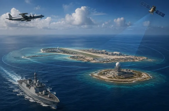
New satellite images reveal fresh construction on Yagong Islet, part of the Paracel Islands in the South China Sea, roughly 14 kilometers from Antelope Reef; a feature analysts say China is turning into its largest military outpost in the region.
Key Facts
|
Topic
|
Key Fact
|
|
Latest development
|
New installations observed on Yagong Island
|
|
Satellite imagery
|
17 August 2026
|
|
Location
|
Paracel Islands, South China Sea
|
|
Nearby project
|
Antelope Reef
|
|
Distance from Antelope Reef
|
About 14 km
|
|
Possible Yagong function
|
Early-warning/surveillance facility
|
|
Antelope artificial island
|
Approximately 6 km long
|
|
Potential runway
|
Around 3 km if completed as analysts expect
|
|
Major maritime treaty
|
UNCLOS, 1982
|
|
EEZ limit
|
Up to 200 nautical miles
|
|
Territorial sea
|
Up to 12 nautical miles
|
|
India's status
|
Not a South China Sea claimant
|
What Has China Built on Yagong Island?
- Commercial satellite imagery indicates that construction on Yagong began around March or April 2026. The latest imagery shows a distinctive multi-pronged installation. Security analysts believe it could eventually host surveillance or early-warning radar systems supporting the much larger development at Antelope Reef.
What is happening at Antelope Reef?
- Antelope Reef is located in the Crescent Group of the Paracel Islands. China began major dredging and reclamation there in late 2025, marking its first significant artificial-island construction in the South China Sea since 2017, according to the Asia Maritime Transparency Initiative (AMTI).
- By August 2026, China had completed the first stage of reclamation, creating an artificial landmass approximately 6 km long. Satellite imagery indicates infrastructure including a wharf, harbour facilities, a helicopter pad and preparation of a long straight section that analysts believe could become a runway.
Why is Antelope Reef Strategically Important?
Antelope Reef lies roughly 162 nautical miles from Sanya in China's Hainan province and about 216 nautical miles from Da Nang, Vietnam. Its location gives it several potential strategic advantages like:
- Control over the Northern South China Sea: A large military-capable base could strengthen China's surveillance and operational reach across the northern part of the South China Sea.
- Potential Air Base: A roughly 3-km runway could potentially support larger military aircraft if completed and equipped accordingly. China already operates substantial aviation infrastructure at several South China Sea outposts.
- Intelligence and Surveillance: Radar and communications installations could improve China's Intelligence, Surveillance and Reconnaissance (ISR) network. China's established South China Sea bases already contain radar, communications, electronic-warfare facilities, aircraft infrastructure and missile-related capabilities.
- Connection with Hainan: The Paracels sits south of Hainan, an important Chinese military hub. Greater infrastructure across the Paracels could therefore create a more integrated network connecting mainland/Hainan facilities with China's offshore positions.
- Taiwan Contingency: Security analysts also view the Paracels as strategically relevant to broader Chinese operations in the region, including a possible Taiwan contingency. This does not mean Antelope Reef is specifically being built for such an operation, but its location could expand China's regional surveillance, logistics and air/sea operating options.
Where is the South China Sea?
- The SCS is a semi-enclosed sea in the western Pacific Ocean. It is surrounded by China, Taiwan, Philippines, Malaysia, Brunei, Indonesia and Vietnam. It connects important parts of the Pacific and Indian Ocean maritime systems, making it one of the world's most strategically significant maritime spaces.
Why is the SCS important?
- Strategic Sea Route: The South China Sea forms part of major shipping routes connecting East Asia, Southeast Asia, Indian Ocean, Middle East and Europe.
- Energy Resources: The region contains existing and potential oil and natural-gas resources.
- Military Importance: The Sea lies at the centre of strategic competition involving China, United States, Southeast Asian claimant states, Japan, Australia and other Indo-Pacific powers.
Who claims what in the South China Sea?
|
Country/Entity
|
Major Areas of Claim/Interest
|
|
China
|
Claims sovereignty over multiple island groups and extensive maritime rights
|
|
Vietnam
|
Claims Paracel and Spratly Islands
|
|
Philippines
|
Claims features and maritime zones in parts of the Spratly region/West Philippine Sea
|
|
Malaysia
|
Claims maritime zones and some Spratly features
|
|
Brunei
|
Claims an EEZ overlapping part of the disputed area
|
|
Taiwan
|
Maintains claims broadly resembling China's historical claim
|
|
Indonesia
|
Not a claimant to the main island groups but rejects Chinese claims overlapping Indonesia's EEZ near the Natuna Islands
|
China's Artificial-Island Strategy
- China's large-scale island-building in the South China Sea accelerated from 2013 onwards. Its most prominent bases include Fiery Cross Reef, Mischief Reef and Subi Reef.
- These installations have substantially expanded China's ability to maintain aircraft, ships, sensors and other military capabilities far from the Chinese mainland.
China's Broader Strategy in the South China Sea
- China's approach can be understood through these elements: Artificial Islands + Coast Guard + Maritime Militia + PLA Navy + Air Power + Radar/ISR + Administrative Control
- AMTI's analysis found that Chinese maritime militia deployments reached record levels across the South China Sea in 2025, particularly around strategically important reefs.
Geopolitical Significance of the Latest Construction
- Expansion of Chinese Surveillance: Radar facilities could provide improved monitoring of aircraft and maritime movements.
- Stronger Military Logistics: Airstrips, ports and support infrastructure would allow China to sustain operations farther from its mainland.
- Anti-Access/Area-Denial (A2/AD) capabilities: Integrated radar, aircraft and missile systems across island bases could contribute to China's wider A2/AD strategy.
- Greater Pressure on Rival Claimants: A larger permanent presence strengthens China's ability to maintain day-to-day operational pressure on other claimant states.
- Increased US–China Competition: The stronger China's military infrastructure becomes, the greater the potential for interaction between Chinese forces and U.S./allied operations.
- Environmental Concerns: Large-scale dredging and reclamation may damage coral reefs, marine habitats, fisheries, biodiversity, and seabed ecosystems.
Prelims MCQ
Q. Which of the following statements about artificial islands under UNCLOS is correct?
A. They automatically generate a 200-nautical-mile EEZ
B. They have the same status as natural islands
C. They do not generate their own territorial sea or EEZ
D. They automatically confer sovereignty over surrounding waters
Mains Practice Question
Q. How does China’s artificial-island strategy affect regional security and the rules-based maritime order?
|
FAQs
What is Yagong Island?
A small feature in the Paracel Islands of the South China Sea.
What is Antelope Reef?
A reef in the Paracel Islands where China is carrying out major reclamation.
Who controls the Paracel Islands?
China currently exercises effective control.
Who also claims the Paracels?
Vietnam and Taiwan claim them.
What is UNCLOS?
The main international treaty governing maritime rights and zones.
|






 Contact Us
  New Batch : 9555124124/ 7428085757
  Tech Support : 9555124124/ 7428085757