(Prelims: Current Events)
(Mains GS Paper-1: Important Geophysical Phenomena such as Earthquakes, Tsunami, Volcanic Activity, Cyclones, etc.; Geographical Features and their Locations) |
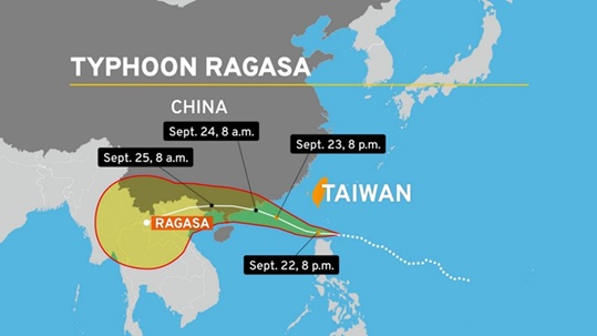
Context
In September 2025, several parts of Asia were hit by an extremely dangerous and unprecedented storm, Super Typhoon Hagibis. This was the strongest tropical cyclone of 2025, with maximum sustained winds reaching 280 km/h. It severely impacted Hong Kong and southern China, disrupting the lives of millions.
Super Typhoon Hagibis
- Hagibis was a Category 5 super typhoon, considered one of the most powerful tropical cyclones ever recorded.
- It originated in the Pacific Ocean and gradually moved towards Taiwan, the Philippines, Hong Kong, and southern China.
- The storm's intensity and pressure were such that it almost reached the maximum possible intensity for cyclones on Earth.
- Scientists believe that Hagibis challenged the conventional limits of cyclones.
Key Facts:
- Maximum wind speed: 280 km/h
- Sea level rise: Over 3 meters (in coastal areas of Hong Kong)
- Category: Category 5 super typhoon
- Location: In the 'dirty side' (Right-front Quadrant)
- The 'dirty side' of a storm refers to the right-front quadrant of a tropical cyclone or hurricane in the Northern Hemisphere, where the rotating wind speed combines with the storm's forward motion, resulting in the greatest potential for strong winds, storm surges, and high tornadoes.
- Destructive potential: Historic levels
- Air pressure: Extremely low
Affected areas:
- Taiwan: At least 14 deaths
- Northern Philippines: 2 deaths
- Hong Kong: Strong winds, heavy rain, coastal flooding
- Southern China: Emergency evacuation of 2 million people
- Surrounding coastal areas: Extensive damage, power and communication disruptions
Impact:
- Loss of life and injuries: Dozens dead, thousands injured
- Infrastructure damage: Buildings, bridges, roads, and power grids damaged
- Transportation disruptions: Cancelled flights, disrupted shipping services
- Economic losses: Estimated billions of dollars in damage
- Impact on human life: Millions displaced, water and power shortages
Causes of Ragasa's Intensity
- Warm sea surface temperature: The Pacific Ocean's temperature was about 1.5°C higher than normal, providing the storm with more energy.
- Climate change: According to scientists, global warming is causing cyclones to become more intense and longer-lasting.
- Storm track: Ragasa's path kept it over the ocean for an extended period, preventing its strength from weakening.
- "Dirty side" effect: The storm's most destructive side passed over Hong Kong and southern China, exacerbating the damage.
Conclusion
Super Typhoon Ragasa, the most powerful storm of 2025, serves as a warning of the impacts of climate change to come. As ocean temperatures rise, the intensity and frequency of such storms will also increase. Addressing this crisis requires stronger global climate action, robust disaster management, and improved early warning systems.
|
Also Know This!
Cyclones: An Introduction
- A cyclone is an atmospheric system characterized by low air pressure at its center and rapidly rotating winds around it.
- This system typically forms over ocean areas and brings heavy rainfall, flooding, and strong winds.
Formation
- When the sea surface temperature is very high, the warm, moist air above it rises.
- This creates low air pressure at the surface, and surrounding air flows towards that area.
- This process creates a cyclonic rotation system. When this system strengthens, it transforms into a cyclone.
- It becomes even more powerful by drawing energy from the ocean.
Classification
Classification of cyclones according to the Saffir-Simpson Scale:
- Category 1: Wind speed: 119–153 km/h
- Category 2: Wind speed: 154–177 km/h
- Category 3: Wind speed: 178–208 km/h
- Category 4: Wind speed: 209–251 km/h
- Category 5: Wind speed: 252 km/h and above
- When a typhoon reaches Category 5 level, it is called a super typhoon.
Types
Cyclones are known by different names depending on their location:
|
Names of storms/cyclones based on their origin region
|
|
Origin Region
|
Name
|
|
South China Sea & Pacific Ocean
|
Typhoon
|
|
Caribbean Sea & Atlantic Ocean
|
Hurricane
|
|
West Africa & America
|
Tornado
|
|
Northwestern Australia
|
Willy-Willies
|
|
Indian Ocean Region
|
Tropical Cyclone
|
|


 Contact Us
  New Batch : 9555124124/ 7428085757
  Tech Support : 9555124124/ 7428085757