Prelims: Location of Anak Krakatau, Sunda Strait, Java and Sumatra, Pacific Ring of Fire, convergent plate boundaries, subduction zones, types of volcanic eruptions and volcano-generated tsunamis.
Mains: GS Paper I (Geography): Plate tectonics, distribution of volcanoes and earthquakes, Pacific Ring of Fire, convergent plate boundaries and geographical features of Indonesia.
GS Paper III (Disaster Management): Volcanic hazards, tsunami risk, volcanic ash and aviation safety, early-warning systems, hazard mapping and disaster preparedness. |
Why in News?
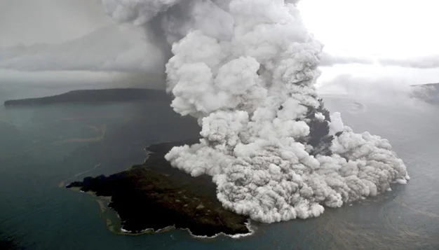
Anak Krakatau entered a prolonged eruptive episode beginning late on 4 September 2026. Indonesia’s Centre for Volcanology and Geological Hazard Mitigation (PVMBG) recorded continuous eruption-related seismic activity from 11:07 p.m. on 4 September until 12:04 a.m. on 6 September, an episode lasting about 25 hours.
Key Facts
|
Particular
|
Details
|
|
Volcano
|
Anak Krakatau
|
|
Country
|
Indonesia
|
|
Location
|
Sunda Strait
|
|
Between
|
Java and Sumatra
|
|
Province
|
Lampung
|
|
Type
|
Active volcanic island
|
|
Current alert level
|
Level III-Siaga
|
|
Major current hazard
|
Volcanic ash, lava and incandescent material
|
|
Major aviation impact
|
Eight airports affected/closed
|
|
Passengers affected
|
Around 170,000
|
|
Historical connection
|
Krakatau eruption of 1883
|
|
Major recent disaster
|
2018 Anak Krakatau flank collapse and tsunami
|
What is Anak Krakatau?
- Anak Krakatau meaning “Child of Krakatau” is an active volcanic island in the Sunda Strait, the waterway separating the Indonesian islands of Java and Sumatra.
- Administratively, it falls within South Lampung Regency, Lampung Province. Indonesia monitors the volcano from observation posts at Kalianda in Lampung and Pasauran in Banten.
Why is the Sunda Strait Important?
- The Sunda Strait separates Sumatra in the west and Java in the east. It also connects the Java Sea with the Indian Ocean. The strait is significant because it lies near an active tectonic boundary and hosts the Krakatau volcanic complex.
What happened during the 2026 Eruption?
- Official Indonesian geological authorities reported eruptions on 2 and 3 July 2026, after a relatively long eruptive pause. Since 2 July, Anak Krakatau has remained at Level III (Siaga).
- Activity continued with Strombolian-type eruptions, producing volcanic ash and incandescent material. On 5 September, authorities described continuous eruptive activity resembling a lava fountain, accompanied by lava flows and rumbling sounds.
- The continuous eruptive episode subsequently ended after approximately 25 hours, but PVMBG maintained Level III because significant volcanic activity continued and further eruptions remained possible.
What is a Strombolian Eruption?
- A type of volcanic eruption characterised by relatively frequent explosive bursts produced when gas bubbles rise through magma and burst near the surface. It can eject gas, volcanic ash, lava fragments and incandescent material. The name comes from Stromboli volcano in Italy.
Scale of Aviation Disruption
- By 7 September, volcanic ash had caused major disruption across western Indonesia. Approximately 1,558 flights were delayed or cancelled across eight airports, affecting roughly 170,000 passengers. Jakarta’s Soekarno-Hatta airport alone accounted for nearly 1,000 affected flights.
- International and domestic connections were affected, including services linking Indonesia with destinations such as Singapore, Doha, Sydney and Kuala Lumpur.
The 2018 Anak Krakatau Tsunami
- On 22 December 2018, part of Anak Krakatau's volcanic edifice collapsed during eruptive activity, generating a tsunami in the Sunda Strait. Indonesia's geological authorities identify the partial collapse of Anak Krakatau as the mechanism behind the tsunami. More than 400 people were killed in the disaster. This event was particularly dangerous because the tsunami was not generated by the conventional mechanism of a large tectonic earthquake.
Why is Indonesia So Volcanically Active?
Indonesia lies along the Pacific Ring of Fire, one of the most tectonically active regions on Earth. The Indonesian archipelago sits near the interaction of several major tectonic plates and microplates. Around Java and Sumatra, the Indo-Australian Plate moves beneath the Sunda/Eurasian margin along the Sunda subduction zone.
What is the Pacific Ring of Fire?
- A broad horseshoe-shaped belt surrounding much of the Pacific Ocean where tectonic activity produces a high concentration of Earthquakes, Volcanoes, Ocean trenches and Island arcs.
- It stretches through areas including New Zealand, Indonesia, Philippines, Japan, Kamchatka, Alaska and Western Americas. Subduction zones are especially important in producing the region's volcanic arcs.
Types of Volcanic Hazards
- Primary Hazards
- Lava flows: molten rock moving across the surface.
- Pyroclastic flows: extremely hot, fast-moving mixtures of gas, ash and volcanic fragments.
- Ash fall: fine volcanic particles deposited over large areas.
- Ballistic projectiles: rocks and incandescent fragments thrown from the crater.
- Volcanic gases: potentially harmful gases released from magma.
- Secondary Hazards
- Lahars: volcanic ash and debris mixed with water, producing destructive mudflows.
- Landslides/flank collapse: instability of the volcanic edifice.
- Tsunamis: possible when volcanic activity or collapse rapidly displaces seawater.
Why Volcanic Ash travel far from a Volcano?
- The height of the eruption column and atmospheric winds determine how far ash can travel.
Explosive eruption → Ash injected high into atmosphere → Upper-level winds transport particles → Ash plume spreads over distant regions
- In the current eruption, ash reached heights reported up to approximately 50,000 feet, helping explain why aviation was affected far beyond the immediate crater area.
Indonesia's Volcano Monitoring System
- Indonesia's volcanoes are monitored principally by the Centre for Volcanology and Geological Hazard Mitigation (PVMBG) under the country's Geological Agency.
- Monitoring can involve seismic instruments, visual observations, satellite imagery, gas measurements, ground deformation and thermal observations.
- Anak Krakatau itself is monitored from observation stations on both the Lampung and Banten sides of the Sunda Strait. Indonesia also uses the MAGMA Indonesia platform for official geological-hazard information.
Disaster Management Response
- Indonesia's National Disaster Mitigation Agency (BNPB) and other authorities activated measures to reduce risks from the eruption.
- Authorities advised people to wear masks, limit outdoor exposure and remain outside the restricted area. Officials also experimented with weather-modification operations aimed at inducing rainfall to help remove ash from the atmosphere.
- The event illustrates the importance of monitoring, early warning, hazard zonation, public communication, transport management, health protection and emergency preparedness.
Why This Event is Important for India
- India also faces volcanic, earthquake and tsunami risks in parts of its territory and surrounding seas. The Andaman and Nicobar Islands lie in a tectonically active zone associated with the broader Sunda-Andaman subduction system.
- The event therefore reinforces the importance of:
- Tsunami early-warning systems
- Seismic monitoring
- Coastal disaster preparedness
- Satellite-based hazard monitoring
- International data sharing
- Aviation management during volcanic ash events
Significance of the Anak Krakatau Eruption
- It demonstrates the continuing geological dynamism of the Sunda volcanic arc.
- The cancellation of more than 1,500 flights illustrates how natural hazards can disrupt global transportation networks and economic activity.
- Anak Krakatau's 2018 history demonstrates the importance of recognising non-earthquake sources of tsunamis.
- The eruption underscores the importance of combining scientific monitoring, hazard mapping, aviation safety, public-health precautions and disaster preparedness.
Prelims MCQ
Q. With reference to Anak Krakatau volcano, consider the following statements:
- It is located in the Sunda Strait between Java and Sumatra.
- It is associated with the Pacific Ring of Fire.
- It emerged from the volcanic system associated with the historic Krakatau eruption.
Which of the statements given above is/are correct?
A. 1 and 2 only
B. 2 and 3 only
C. 1 and 3 only
D. 1, 2 and 3
Mains Practice Question
Q. Why is Indonesia highly prone to volcanic eruptions? Discuss the major hazards associated with volcanic activity.
|
FAQs
What is Anak Krakatau?
Anak Krakatau is an active volcanic island in Indonesia. Its name means “Child of Krakatau.”
What happened at Anak Krakatau in 2018?
A major flank collapse during volcanic activity displaced seawater and generated a deadly tsunami in the Sunda Strait.
What is a Strombolian eruption?
It is an eruption characterised by intermittent explosive bursts that can eject lava fragments, volcanic ash and gases.
What is the Sunda Strait?
The Sunda Strait is a waterway separating the Indonesian islands of Java and Sumatra and connecting the Java Sea with the Indian Ocean.
Where is Anak Krakatau located?
It is located in the Sunda Strait between Java and Sumatra in Indonesia.
|







 Contact Us
  New Batch : 9555124124/ 7428085757
  Tech Support : 9555124124/ 7428085757