Why is it in the News?
- Recently, a face-off occurred between Indian and Chinese soldiers near the Line of Actual Control (LAC) in the Upper Subansiri district of Arunachal Pradesh along the India–China border.
- China attempts to alter the existing status quo in its favour through military pressure, infrastructure development, and other unconventional methods.
Major Areas of the India–China Border Dispute
1. Line of Actual Control (LAC)
- Line of Actual Control (LAC): The line that separates the areas under the actual control of India and China.
- Ceasefire line: Following the 1962 India–China War, the armies of both countries were deployed along the disputed border.
- After the 1962 India–China War, the term LAC was initially used in reference to the western sector.
- Since the 1990s, it has been used to refer to the entire line of actual control between the two countries.
- The LAC received formal recognition through the India–China agreements signed in 1993 and 1996.
2. McMahon Line
- The McMahon Line is the boundary line between India and Tibet.
- It was established under the 1914 Simla Convention involving representatives of British India and Tibet.
- In 1937, a Survey of India map depicted the McMahon Line as India's official boundary.
- China refuses to recognise the 1914 Simla Convention.
- Chinese official maps claim the area south of the McMahon Line, approximately 56,000 square miles, as part of the Tibet Autonomous Region. China refers to this area as South Tibet.
3. Aksai Chin
- Aksai Chin is located just below the Kunlun Mountains.
- It is a salt desert.
- The name is commonly interpreted as meaning the “desert of the white stony valley.”
- Aksai Chin includes a river and a lake bearing the same name.
- Geographically, it forms part of the Tibetan Plateau.
- It is largely uninhabited, with no permanent settlements.
- Historically, Aksai Chin provided a route connecting India with the Silk Road.
- The trade route from India to Turkistan passed through Ladakh and Aksai Chin to Kashgar.
- China took control of Aksai Chin during the 1950s.
- Johnson Line: Places Aksai Chin within Indian territory.
- Macartney–MacDonald Line: Places Aksai Chin within Chinese territory.
4. Daulat Beg Oldi (DBO)
- Daulat Beg Oldi is located in the Ladakh region of India.
- The Chip Chap River lies to its south.
- Historically, it served as a stopping point on the trade route between India and Eastern Turkistan.
5. Pangong Tso Lake
- Pangong Tso is approximately 134 km long and lies at an altitude of more than 14,000 feet in the Himalayas.
- Approximately 45 km of the lake's length lies within India.
- Approximately 90 km lies within China.
- The LAC passes through the lake.
6. Galwan Valley
- Galwan Valley is located near the India–China border between Ladakh and Aksai Chin.
- The LAC separates Aksai Chin from areas under Indian control.
- Galwan Valley has been a source of India–China tensions since 1962.
- The Galwan River originates in Aksai Chin and joins the Shyok River.
7. Doklam
- Doklam lies between China and Bhutan, near the Sikkim border.
- Both Bhutan and China claim the area.
- India supports Bhutan's claim.
8. Chumbi Valley
- Chumbi Valley is located in Tibet.
- The boundaries of India, Bhutan, and Tibet meet in the surrounding region.
- The Nathu La and Jelep La passes are located in this area.
- The valley is approximately 50 km from the Siliguri Corridor.
9. Tawang
- Tawang is located in Arunachal Pradesh and is an important Buddhist religious centre.
- China argues that Tawang has strong cultural similarities with Tibet and should be considered part of Tibet.
- In 1914, an agreement was reached between representatives of British India and Tibet.
- The agreement established the boundary that India recognises in the region, including Tawang in Arunachal Pradesh.
- In 1962, Chinese forces occupied Tawang temporarily.
- China subsequently withdrew, and Indian forces regained control of the area.
10. Nathu La and Cho La
- The Nathu La and Cho La clashes were military confrontations between India and China in 1967.
- These clashes took place along the Sikkim–Tibet border, when Sikkim was an Indian protectorate and Tibet was under Chinese control.
- Nathu La and Jelep La are important historical trade passes between India and Tibet.
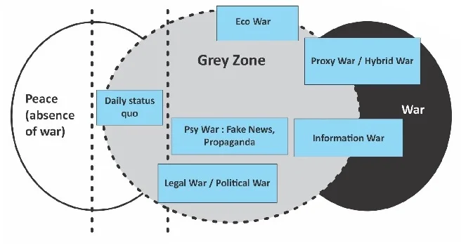
What Is Grey-Zone Warfare?
- Grey-zone warfare is a strategy in which a country puts pressure on an adversary through political, economic, military, cyber, and legal measures without engaging in a direct, full-scale war.
- Its objective is to gradually change the ground situation and balance of power in its favour, making it difficult for the opposing country to respond effectively.
- In simple terms, grey-zone warfare involves exploiting the space between peace and conventional war to undermine another country's interests.
Major Characteristics of Grey-Zone Warfare
- Limited military pressure: Taking small military steps instead of launching a full-scale war.
- Ambiguity: Conducting activities in ways that make it difficult to classify them as clear acts of war.
- Gradual alteration of the status quo: Expanding influence in disputed areas through patrolling, construction, and other activities.
- Legal and political pressure: Strengthening territorial claims through laws, propaganda, and diplomacy.
- Avoiding the costs of war: Gaining strategic advantages without taking the risks associated with a major military conflict.
Major Methods Used in China's Grey-Zone Warfare Strategy
1. Development of Military Infrastructure
- Following the 2020 eastern Ladakh crisis, China accelerated the development of roads, railways, airports, and heliports near the border.
- These facilities enable the Chinese military to move troops, weapons, and other military resources rapidly.
- Infrastructure development in border areas enhances China's military capabilities and its ability to maintain a prolonged presence along the border.
2. The “Nibble and Negotiate” Strategy
- This strategy involves gradually gaining advantages through small steps while continuing negotiations.
- China may attempt to influence the ground situation through patrolling, construction, and an increased military presence in border areas.
- Since each individual step may appear limited, responding to it can be difficult. However, the cumulative effect of these actions may become significant over time.
3. Development of Border Villages
- China is developing modern villages in Tibet and other border regions.
- These villages help maintain civilian populations, improve connectivity, and strengthen administrative presence in border areas.
- Some villages may also support military logistics and border surveillance.
4. The “Three Warfares” Strategy
China's military strategy gives particular importance to three forms of warfare:
- Public Opinion Warfare: Using the media and propaganda to build public support for China's actions.
- Psychological Warfare: Creating psychological pressure on the opposing country's soldiers, leadership, and population.
- Legal Warfare: Using domestic laws and legal arguments to justify territorial claims.
5. Renaming Places and Using Maps
- China has continued to issue Chinese names for certain places in Arunachal Pradesh.
- The objective is to reinforce its territorial claims at the political and administrative levels.
- Maps, place names, and official documents can therefore be used as instruments of strategic pressure.
6. Expanding Economic and Diplomatic Influence
- China expands its influence in Asia, Africa, and the Indian Ocean region through investment, trade, connectivity projects, and security cooperation.
- China's strategic partnership with Pakistan may create security challenges for India on two fronts.
- Economic dependence and regional influence can be used as instruments in broader geopolitical competition.
7. Cyber and Information Warfare
- Cyberattacks, misinformation, and digital platforms may be used to influence an adversary's institutions and decision-making processes.
- Identifying the source and purpose of such attacks can be difficult.
- Dealing with these threats requires strong technological and intelligence capabilities.
Major Challenges Facing India
1. Differences over the Demarcation of the LAC
- India and China have different perceptions of the LAC.
- Uncertainty regarding the actual line of control in several areas can lead to face-offs between soldiers.
- Since 2020, issues relating to patrolling arrangements and access to traditional patrol points have also emerged in some areas.
2. Differences in Military Capabilities and Infrastructure
- China has extensively developed roads, railways, airports, and other facilities in border areas.
- India also needs to continuously improve connectivity, surveillance, and logistical facilities in difficult mountainous terrain.
3. Lack of Coordination among Different Agencies
- Both the Indo-Tibetan Border Police (ITBP) and the Indian Army play important roles along the India–China border.
- The ITBP functions under the administrative control of the Ministry of Home Affairs, whereas the Indian Army comes under the Ministry of Defence.
- Effective coordination, clearly defined responsibilities, and a rapid decision-making process are essential.
4. Surveillance and Intelligence Challenges
- Monitoring every activity in difficult mountainous terrain is challenging.
- Delays in receiving information may slow the deployment of troops and resources.
- Drones, satellites, radars, and modern communication systems are therefore crucial.
5. Diplomatic Pressure and Lack of Trust
- High-level dialogue can help reduce tensions, but it does not automatically resolve the border dispute permanently.
- India must maintain military preparedness and credible deterrence alongside diplomatic engagement.
What Should India Do to Counter Grey-Zone Warfare?
1. Develop an Integrated National Strategy
- India should develop a clear, long-term national strategy to address security challenges arising from China.
- This strategy should coordinate the armed forces, border security forces, intelligence agencies, foreign policy, and economic policy.
- Its objective should not merely be to respond to individual incidents, but also to prevent China from unilaterally changing the status quo.
2. Strengthen Border Management
- Improve coordination between the ITBP and the Indian Army.
- Clearly define responsibilities and authority along the border.
- Expand modern surveillance equipment, communication systems, and rapid-response capabilities.
- Provide border security personnel with the necessary training and modern equipment.
3. Develop Border Infrastructure
- Accelerate the construction of border roads, tunnels, bridges, and airstrips.
- Ensure rapid movement of troops and supplies to forward posts.
- Develop electricity, communication, healthcare, and livelihood facilities in border villages.
- Strengthen administrative presence in border areas through the participation of local communities.
4. Enhance Surveillance and Technological Capabilities
- Increase the use of satellite imagery, drones, sensors, and modern communication systems.
- Develop mechanisms for sharing intelligence in real time.
- Strengthen capabilities to counter cyber threats and information warfare.
5. Establish Clear Command and Control Mechanisms
- Clearly define operational responsibilities among the agencies deployed along the border.
- Speed up decision-making and resource mobilisation during crises.
- Promote joint exercises and shared operational procedures between the Army and the ITBP.
6. Pursue Balanced and Firm Diplomacy
- India should keep channels of communication with China open while treating peace along the border as a prerequisite for the normalisation of bilateral relations.
- Emphasise compliance with border agreements and established mechanisms.
- Maintain the capability to respond appropriately and promptly to any unilateral attempt to change the status quo.
- Strengthen cooperation with strategic partners and regional forums.
7. Strengthen Economic and Strategic Self-Reliance
- Reduce excessive dependence on external sources for critical technologies, defence equipment, and supply chains.
- Promote domestic defence production and research.
- Enhance maritime surveillance and regional cooperation in the Indian Ocean.
- Link economic capabilities with national security and diplomatic influence.
The Way Forward for India
- India's strategy should not be limited to responding to every Chinese action. It should create conditions in which it becomes difficult and costly for China to change the status quo through incremental steps.
- This requires simultaneous action at three levels:
- Strategic level: Strengthen military preparedness, surveillance, and deterrence.
- Diplomatic level: Effectively use dialogue, border agreements, and regional cooperation.
- Domestic level: Improve border infrastructure, technology, economic capacity, and institutional coordination.
Conclusion
Grey-zone warfare represents a modern security challenge in which a country's territorial and strategic interests can be affected even without direct warfare. To counter China's strategy effectively, India must focus not only on military strength but also on diplomatic firmness, technological capabilities, economic self-reliance, and improved border management.
An integrated national strategy and credible deterrence can provide the foundation for maintaining peace along the LAC and safeguarding India's territorial integrity.
Mains Examination Question
Question: What do you understand by grey-zone warfare? Discuss its major characteristics and the challenges it poses for India in the context of the India–China border.
Preliminary Examination Question
Question 1. Consider the following statements regarding Grey-Zone Warfare:
- It involves putting pressure on an adversary without engaging in direct, full-scale military warfare.
- It involves the use of military power alone.
- Its objective may be to gradually change the status quo in one's favour.
Select the correct answer using the code given below:
(a) 1 and 2 only
(b) 1 and 3 only
(c) 2 and 3 only
(d) 1, 2 and 3
|