Prelims: NavIC, IRNSS, satellite navigation, L5 and S-bands, NVS-03
Mains: Space technology, national security, self-reliance, disaster management and digital connectivity
Keywords: NavIC, NVS-03, ISRO, IRNSS, GPS, satellite navigation, atomic clock |
Why in the News?
- ISRO’s third next-generation navigation satellite, NVS-03, is scheduled for launch on October 30, 2026. It could help restore NavIC’s ability to independently determine a user’s position.
- The government told Parliament that only three NavIC satellites were providing Positioning, Navigation and Timing (PNT) services. At least four operational satellites are needed for basic positioning. NavIC could therefore not provide standalone positioning, although its timing service remained functional.
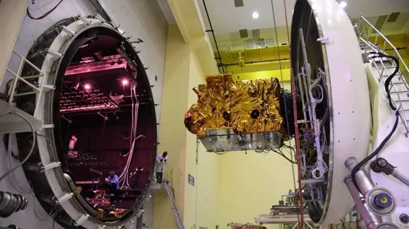
What Is NavIC?
- NavIC, or Navigation with Indian Constellation, is India’s regional satellite-based navigation system. It was earlier known as the Indian Regional Navigation Satellite System (IRNSS).
- NavIC is designed to provide positioning, navigation and timing services across India and up to about 1,500 km beyond the Indian boundary. Its core constellation is designed around seven satellites.
Why Was NavIC’s Service Affected?
- NavIC needs signals from at least four operational satellites to provide basic positioning. In July 2026, the government said that three satellites IRNSS-1B, IRNSS-1I and NVS-01 were providing PNT services. As a result, NavIC could not independently determine a user’s position, though its timing service continued to work.
- Some earlier NavIC satellites faced problems with their atomic clocks or reached the end of their mission lives. IRNSS-1F completed its 10-year designed mission life, and its onboard atomic clock stopped functioning. The newer satellite NVS-02 also failed to reach its intended final orbit because the required orbit-raising manoeuvres could not be completed.
What Could NVS-03 Change?
NVS-03 is the third satellite in NavIC’s second-generation series. Its launch is scheduled for October 30, 2026. If it is successfully placed in orbit and becomes operational, the number of NavIC satellites providing PNT services could rise to four. This could make standalone positioning possible again.
NVS-03 could:
- Help restore NavIC’s standalone positioning service.
- Strengthen India’s regional navigation capability.
- Support transport, vehicle tracking, maritime navigation and emergency services.
- Add to the planned expansion of NavIC through future satellites such as NVS-04 and NVS-05.
How Does NavIC Work?
NavIC satellites transmit precisely timed signals to Earth. A receiver estimates its position and time by measuring how long the signals take to arrive. According to ISRO, at least four operational satellites are needed for basic positioning.
NavIC provides two types of services:
- Standard Positioning Service (SPS): For civilian and general use.
- Restricted Service (RS): An encrypted service for authorised users.
NavIC signals are available in the L5 and S-bands. The second-generation satellites are also introducing the L1 band to support civilian use and improve compatibility with other global navigation satellite systems.
NavIC and GPS: Key Differences
|
Feature
|
NavIC
|
GPS
|
|
Full name
|
Navigation with Indian Constellation
|
Global Positioning System
|
|
Operated by
|
India
|
United States
|
|
Coverage
|
India and the region extending about 1,500 km beyond its boundary
|
Global
|
|
Main purpose
|
Regional PNT services centred on India
|
PNT services worldwide
|
|
Services
|
Civilian SPS and authorised-user RS
|
Civilian and authorised-user services
|
NavIC is best understood as a regional system and complement to global systems such as GPS, rather than as a global replacement. ISRO says NavIC’s SPS signals can work alongside GPS, GLONASS, Galileo and BeiDou.
Significance of NavIC
- Strategic autonomy: An indigenous navigation system gives India its own source of positioning and timing services. This is important for national security and strategic applications.
- Transport and rail services: NavIC can support transport, vehicle tracking and train-related services. The Indian Express reports that a fully operational NavIC system could help meet the goal of real-time tracking for around 12,000 trains.
- Maritime safety and disaster alerts: NavIC also supports one-way short-message broadcasting. ISRO says this capability can be used to send emergency warnings to fishermen at sea, including in areas without terrestrial network coverage.
- Technology and industry: New satellites and compatible receivers can help India build domestic capabilities in navigation chips, consumer devices and space systems.
Key Challenges
- Limited number of satellites: Standalone positioning requires enough operational satellites.
- Clock and orbit risks: Problems with atomic clocks or orbital manoeuvres can interrupt service.
- Post-launch work: A satellite must be placed in its intended orbit and checked before it can provide operational services.
- Receiver availability: NavIC’s benefits depend on phones, vehicles and other devices being able to receive its signals.
- Continuity and backup: Reliable service requires timely satellite replacements and sufficient backup capacity.
Way Forward
- Clearly communicate NVS-03’s orbital deployment, testing and operational status after launch.
- Develop NVS-04 and NVS-05 on schedule to expand NavIC’s satellite capacity and resilience.
- Continue developing indigenous atomic clocks and other critical satellite components.
- Increase the use of NavIC-compatible receivers in mobile phones, vehicles and public services.
- Preserve compatibility with other GNSS systems while strengthening NavIC’s independent capabilities.
Conclusion
- NavIC is an important part of India’s regional navigation and timing capability. The successful launch and commissioning of NVS-03 could be a significant step towards restoring standalone positioning.
- Reliable service over the long term will also require enough operational satellites, strong indigenous technology and wider adoption of NavIC-compatible devices.
Prelims MCQ
Consider the following statements about NavIC:
- It is India’s regional satellite navigation system.
- Its service area extends about 1,500 km beyond India’s boundary.
- Its Restricted Service is openly available to all civilian users.
Which of the statements given above is/are correct?
A. 1 and 2 only
B. 2 and 3 only
C. 1 and 3 only
D. 1, 2 and 3
Mains Question
Why is NavIC important for India’s strategic autonomy and civilian services? Discuss the opportunities associated with NVS-03 and the challenges to ensuring the continuity of NavIC services.
|
FAQs
1. What is the full form of NavIC?
NavIC stands for Navigation with Indian Constellation. It was earlier called IRNSS.
2. Is NavIC India’s GPS?
NavIC is India’s own satellite navigation system, but it is regional rather than global. Its main service area covers India and the surrounding region.
3. When is NVS-03 scheduled to launch?
NVS-03 is scheduled for launch on October 30, 2026. The launch and operational schedule may change.
4. Why could NavIC not provide standalone positioning?'
In July 2026, the government said that three satellites were providing PNT services, while at least four operational satellites were needed for basic positioning. The timing service remained functional.
5. Does a disruption to NavIC mean that phone location services stop working?
Not necessarily. Many devices also use other GNSS signals, including GPS.
|



 Contact Us
 New Batch : 9555124124/ 7428085757
 Tech Support : 9555124124/ 7428085757
