Prelims : Geography + CA
Mains : GS 3 – Disaster Management, Science & Technology, Internal Security |
Why in News ?
- The Multi-Hazard Early Warning Decision Support System marks a major technological shift in India’s weather forecasting and disaster risk reduction framework, reflecting the growing integration of digital tools in governance.
- It highlights India’s transition toward a proactive, anticipatory disaster management approach, where early warnings and real-time data guide policy and response.
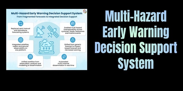
About Multi-Hazard Early Warning Decision Support System
- The Multi-Hazard Early Warning Decision Support System is an advanced digital forecasting and decision-support platform developed by the India Meteorological Department, combining open-source technology with in-house scientific expertise.
- It functions under Mission Mausam, which aims to modernise India’s meteorological infrastructure and improve climate services delivery.
- Launched in January 2024, the system integrates multiple datasets, forecasting models, and analytical tools into a single unified interface, enabling seamless forecasting and dissemination.
- It operates in real time using GIS-based mapping tools, allowing forecasters and administrators to visualise risks spatially and take targeted decisions.
- The initiative is overseen by the Ministry of Earth Sciences (MoES), which is responsible for strengthening India’s scientific and disaster preparedness ecosystem.
Key Features of the System
1. Automated Weather Data Processing
- The system automates over 90% of weather data collection, quality control, and integration, significantly reducing human intervention and enhancing efficiency.
- This enables faster detection of evolving weather phenomena, such as cyclones, heatwaves, and extreme rainfall events, improving early warning capabilities.
2. Enhanced Use of Forecast Models
- More than 95% of inputs from Numerical Weather Prediction (NWP) models are utilised, ensuring forecasts are based on comprehensive, high-resolution datasets.
- This improves the accuracy, reliability, and granularity of multi-hazard risk assessments, especially in complex weather scenarios.
3. Re-engineered Forecasting Workflow
- The forecasting process has been completely restructured into an integrated digital workflow, ensuring seamless coordination from data input to warning dissemination.
- This allows for real-time alerts and quicker response generation, which is critical in disaster situations.
4. Increased Forecast Lead Time
- Forecast lead time has been extended from 5 days to 7 days, giving authorities and communities additional time to prepare and respond effectively.
- This enhances evacuation planning, resource allocation, and disaster mitigation strategies.
5. Faster Forecast Preparation
- The time required to generate forecasts has been reduced by approximately 3 hours, enabling quicker communication of warnings.
- This is particularly important in rapid-onset disasters, where timely information can save lives.
6. GIS-Based Visualisation and Decision Support
- Integration of Geographic Information System (GIS) tools allows for spatial mapping of hazards and vulnerabilities, improving situational awareness.
- This enables location-specific, data-driven decision-making, enhancing the effectiveness of disaster response.
Significance of the System
1. Shift from Reactive to Proactive Disaster Management
- The system enables a transition from post-disaster response to pre-disaster preparedness, aligning with global disaster risk reduction frameworks.
2. Integration of Technology in Governance
- It showcases the effective use of digital technologies such as GIS, big data, and predictive modelling in strengthening governance mechanisms.
3. Reduction in Disaster Losses
- Timely and accurate warnings can significantly reduce :
- Human casualties
- Infrastructure damage
- Economic losses
4. Strengthening Climate Resilience
- With increasing climate variability, the system enhances India’s adaptive capacity and resilience to extreme weather events.
5. Improved Inter-Agency Coordination
- A unified platform enables better coordination among :
- Disaster management authorities
- State governments
- Emergency response agencies
Challenges and Limitations
1. Last-Mile Connectivity Issues
- Despite improved forecasting, effective dissemination to remote and vulnerable communities remains a challenge, limiting impact on the ground.
2. Digital Infrastructure Gaps
- Uneven digital infrastructure across regions may affect the system’s accessibility and efficiency.
3. Capacity Building Needs
- Effective utilisation requires trained personnel and institutional capacity, especially at the local level.
4. Data Integration Complexities
- Integrating diverse datasets in real time can pose technical and coordination challenges, particularly in high-pressure scenarios.
Way Forward
- Strengthen last-mile communication systems using mobile alerts and community networks
- Invest in AI and advanced predictive analytics for improved accuracy
- Enhance training and capacity building of local authorities
- Improve data-sharing and inter-agency coordination mechanisms
Practice Questions
Prelims :
Q. Which of the following best describes the Multi-Hazard Early Warning Decision Support System ?
(a) A disaster relief fund
(b) A real-time weather forecasting and early warning platform
(c) A satellite launch programme
(d) A climate mitigation scheme
Mains :
“Discuss how digital technologies like the Multi-Hazard Early Warning Decision Support System can transform disaster management in India.”
FAQs
Q1. What is the Multi-Hazard Early Warning Decision Support System ?
It is a digital platform developed by the India Meteorological Department to provide real-time, integrated early warnings for multiple weather hazards using advanced data analytics and GIS tools.
Q2. Under which initiative has this system been developed ?
It has been developed under Mission Mausam, which focuses on modernising India’s weather forecasting infrastructure.
Q3. Which ministry oversees this system ?
The system operates under the Ministry of Earth Sciences (MoES).
Q4. How does it improve disaster management ?
It enhances preparedness through real-time alerts, longer forecast lead time (up to 7 days), and faster decision-making, reducing disaster impact.
Q5. What technologies are used in the system ?
It uses :
- GIS for spatial mapping
- Numerical Weather Prediction (NWP) models
- Automation and real-time data processing
|


 Contact Us
  New Batch : 9555124124/ 7428085757
  Tech Support : 9555124124/ 7428085757