Prelims: Map Projections, Mercator Projection, Equal Earth Projection, African Union, United Nations General Assembly
Mains: GS-I World Geography | GS-II International Institutions, Global South and Representation
Keywords: Mercator Projection, Equal Earth Projection, Map Projection, Cartographic Distortion, African Union, Togo, UN General Assembly, Global South, Cartographic Representation, Equatorial Regions |
Why in News?
The United Nations General Assembly (UNGA) has adopted the “Correct the Map” resolution, calling for greater use of world maps that represent the relative sizes of continents more accurately, particularly Africa.
Important Point
- The resolution was championed by Togo on behalf of the African Group and received overwhelming support, with 164 countries voting in favour, six abstaining and the United States casting the only vote against it.
- The initiative seeks to reduce reliance on the centuries-old Mercator projection for general-purpose world maps and promote alternatives such as the Equal Earth projection.
- The resolution is non-binding, meaning countries are not legally required to abandon the Mercator projection.
What is the ‘Correct the Map’ Initiative?
- The Correct the Map initiative is an Africa-led campaign seeking a more accurate representation of the relative size of continents on world maps.
- It argues that commonly used Mercator-based maps significantly distort the size of landmasses, especially those located near the Equator.
- The initiative has been strongly backed by the African Union (AU), which argues that inaccurate cartographic representation has contributed to the visual and symbolic minimisation of Africa.
- The African Union has encouraged international organisations, educational institutions, publishers and digital platforms to progressively use maps that more accurately represent actual land areas.
What is the Mercator Projection?
- The Mercator Projection is a cylindrical map projection developed by Flemish cartographer Gerardus Mercator in 1569.
- It was primarily designed to assist maritime navigation.
- One of its biggest advantages is that it preserves angles and directions, allowing sailors to plot constant compass bearings as straight lines.
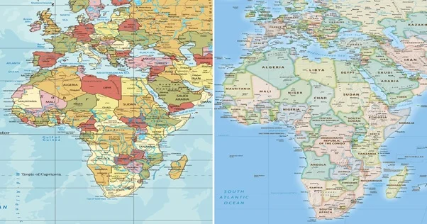
Africa vs Greenland
- One of the clearest examples of Mercator distortion is the comparison between Africa and Greenland.
- Africa covers roughly 30 million sq km, while Greenland covers only about 2.2 million sq km.
- Africa is around 14 times larger than Greenland, even though conventional Mercator maps can make the two appear broadly comparable in size.
Why Does the Mercator Projection Distort Size?
Earth is a three-dimensional sphere-like body, while a conventional map is a two-dimensional flat surface. Converting the Earth's curved surface into a flat map inevitably creates some form of distortion.
A map projection may attempt to preserve:
- Area
- Shape
- Direction
- Distance
But no flat world map can perfectly preserve all these characteristics simultaneously. The Mercator projection prioritises angles and direction, making it useful for navigation, but sacrifices the accurate representation of area.
What is the Equal Earth Projection?
- The Equal Earth Projection is an equal-area world map projection designed to represent the relative sizes of countries and continents more accurately.
- Unlike the Mercator projection, it preserves the proportional area of landmasses.
- This means: Africa appears larger, Greenland appears smaller, Europe appears relatively smaller, High-latitude regions lose their exaggerated size
- The UN resolution promotes Equal Earth as a relevant option for improving the accuracy of general cartographic representation.
Mercator vs Equal Earth Projection
|
Feature
|
Mercator Projection
|
Equal Earth Projection
|
|
Main Purpose
|
Navigation
|
General world representation
|
|
Developed
|
1569
|
2018
|
|
Area Preservation
|
No
|
Yes
|
|
Shape/Angle
|
Locally preserved
|
Some distortion
|
|
Polar Regions
|
Highly enlarged
|
More proportionate
|
|
Africa
|
Appears relatively smaller
|
Reflects actual relative area
|
|
Navigation
|
Highly useful
|
Not primarily designed for navigation
|
Why is Africa at the Centre of the Debate?
Africa is particularly affected because much of the continent lies near the Equator, while Europe, Russia, Canada and Greenland extend into higher latitudes.
The African Union argues that the issue extends beyond geography because repeated visual representations can influence how societies perceive the economic, political and strategic importance of different regions.
Why is the Resolution Significant?
1. Cartographic Accuracy: It promotes maps that better reflect the actual relative areas of countries and continents.
2. Representation of Africa: The initiative seeks to correct the longstanding visual underrepresentation of the African continent.
3. Education: School textbooks and educational maps could increasingly adopt equal-area projections.
4. Digital Mapping: The initiative could encourage digital platforms and technology companies to reconsider how the world is visually represented.
5. Global South: The debate reflects a wider demand from developing countries for more equitable representation in global institutions, knowledge systems and international narratives.
- Voting in the UN General Assembly
- The resolution received overwhelming international support:
- In Favour: 164 countries
- Against: 1 country – United States
- Abstentions: 6
France was among the countries supporting the initiative and announced plans to move away from Mercator for relevant map representations.
Why Did the United States Oppose the Resolution?
The United States was the only country to vote against the resolution. According to reports, the US argued that the proposal promoted an “ideological agenda” and diverted attention from more pressing international challenges related to peace, prosperity and international relations.
Role of Togo and the African Union
- Togo played the leading diplomatic role in advancing the initiative internationally.
- The African Union had earlier supported the broader effort to correct the representation of Africa on world maps.
Significance for India
- India has consistently emphasised greater representation of the Global South in international governance.
- The debate is relevant for India because it highlights a broader principle: Representation should reflect contemporary realities rather than inherited historical structures.
- This principle also appears in India's advocacy for reform of institutions such as the United Nations Security Council and other multilateral organisations.
Challenges
- No Perfect Flat Map: Every map projection introduces some form of distortion.
- Global Standardisation: Changing educational and institutional mapping practices worldwide would require coordination.
- Digital Platforms: Online mapping systems use different projections depending on purpose and zoom level.
- Navigation Requirements: Mercator remains valuable for certain navigational applications.
Way Forward
- The focus should not be on completely eliminating one projection but on using the appropriate projection for the appropriate purpose.
- Educational institutions can increasingly use equal-area maps when teaching comparative geography.
- Digital platforms can provide users with different projection options.
- International organisations can develop clear cartographic standards based on scientific requirements.
Conclusion
- The UN-backed “Correct the Map” initiative represents more than a debate over cartography. It highlights how the way geography is visually represented can influence perceptions of countries, continents and their place in the international system.
- The shift from Mercator towards equal-area projections such as Equal Earth seeks to provide a more proportionate representation of Africa and other regions. However, rather than declaring one map universally correct, the debate underlines a fundamental geographical principle: different map projections serve different purposes, and the projection should be chosen according to the information being represented.
Prelims MCQ
Q. With reference to map projections, consider the following statements:
- The Mercator projection preserves angles and is useful for navigation.
- The Mercator projection accurately preserves the relative area of continents.
- Equal Earth is an equal-area map projection.
Which of the statements given above are correct?
(a) 1 only
(b) 1 and 2 only
(c) 1 and 3 only
(d) 1, 2 and 3
Mains Question
“Map projections are not merely technical representations of geography but can also influence perceptions of geopolitical importance.” Discuss in the context of the UN-backed ‘Correct the Map’ initiative.
|
FAQs
1. What is the Correct the Map resolution?
It is a UN General Assembly resolution promoting more accurate cartographic representation of continents, particularly Africa, and encouraging greater use of alternatives to the Mercator projection.
2. Which country led the initiative?
Togo championed the initiative on behalf of the African Group, with strong backing from African Union members.
3. How many countries supported the resolution?
164 countries voted in favour, while six abstained and the United States was the only country to vote against it.
4. What is wrong with the Mercator projection?
It exaggerates the size of regions closer to the poles and therefore makes equatorial regions such as Africa appear relatively smaller.
5. Is Africa really 14 times larger than Greenland?
Yes. Africa's land area is roughly 14 times that of Greenland, although Mercator maps can make them appear broadly similar in size.
|





 Contact Us
  New Batch : 9555124124/ 7428085757
  Tech Support : 9555124124/ 7428085757