| Prelims: (Defence Exercises + CA) Mains: (GS 2 – International Relations; GS 3 – Security, Defence Cooperation) |
The Indian Navy is participating in Exercise Sea Dragon 2026, a United States Navy-led multinational anti-submarine warfare (ASW) exercise aimed at strengthening maritime security and interoperability among Indo-Pacific partner nations.

The Indo-Pacific region has emerged as a critical geopolitical and maritime zone, witnessing increasing naval activities, strategic competition, and concerns over sea-lane security.
With the rise in submarine deployments and underwater threats, nations are focusing on enhancing anti-submarine warfare (ASW) capabilities.
In this context, the United States has been conducting multilateral naval exercises to build coordination among like-minded countries, particularly in response to evolving maritime challenges.
Exercise Sea Dragon is one such initiative that reflects deepening defence cooperation among Indo-Pacific democracies.
ASW involves detection, tracking, and neutralisation of enemy submarines.
FAQs1. What is Exercise Sea Dragon ? It is a US Navy-led multinational anti-submarine warfare exercise conducted annually to enhance maritime security cooperation. 2. Where is Sea Dragon conducted ? It is held at Andersen Air Force Base in Guam, located in the Western Pacific. 3. Which countries participate in Sea Dragon 2026 ? The USA, India, Australia, Japan, and New Zealand are participating. 4. What is the main objective of the exercise ? To improve anti-submarine warfare capabilities and interoperability among participating nations. 5. What is the Dragon Belt award ? It is awarded to the nation that achieves the highest score based on performance during the exercise. |
| Prelims: (Geography + Current Affairs) Mains: (GS 1 – Indian Heritage & Culture; GS 3 – Environment, Conservation) |
The hill region surrounding Kalinjar Fort has been officially declared a National Geo-Heritage Site by the Geological Survey of India, recognising its geological and historical significance.
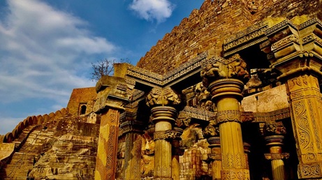
India possesses a rich combination of geological diversity and cultural heritage, where many historical sites are closely linked with unique landforms.
Geo-heritage sites are designated to preserve significant geological features, promote scientific research, and encourage sustainable tourism.
The Vindhyan region, where Kalinjar is located, is known for its ancient rock formations, dating back hundreds of millions of years, making it important for understanding Earth's geological evolution.
The declaration of Kalinjar region as a geo-heritage site reflects a growing emphasis on integrated conservation of natural and cultural heritage.
FAQs1. What is Kalinjar Fort known for ? It is known for its strategic location, historical importance, and religious significance. 2. Why was the Kalinjar region declared a Geo-Heritage Site ? Due to its unique geological formations and scientific importance. 3. Which dynasty significantly developed the fort ? The Chandela dynasty played a major role in its development. 4. What is the significance of the Neelkanth Temple ? It is a प्रमुख religious site dedicated to Lord Shiva with unique architectural features. 5. What is the role of the Geological Survey of India (GSI) ? It identifies and preserves geological heritage sites and promotes geoscientific research in IndSia. |
| Prelims: (Geography + CA) Mains: (GS 1 – Physical Geography; GS 3 – Environment, Disaster Management) |
Recent scientific studies have traced the evolution and formation history of the Ladakh Magmatic Arc (LMA) in the north-western Himalaya, providing deeper insights into plate tectonics and mountain-building processes.
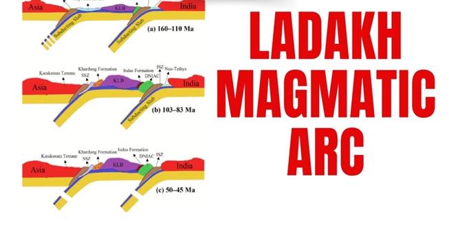
The Himalayan region is one of the most geologically active zones in the world, shaped by the collision between the Indian Plate and the Eurasian Plate.
Before this collision, a vast ocean called the Neo-Tethys Ocean existed between the two plates.
The Ladakh Magmatic Arc formed as a result of complex geological processes associated with this ocean’s closure.
The LMA was formed due to the process of Subduction.
Mechanism:
Characteristics:
Developments:
Significance:
Features:
Interpretation:
FAQs1. What is the Ladakh Magmatic Arc ? It is a belt of igneous rocks formed due to ancient volcanic activity in the Trans-Himalayan region. 2. How was the LMA formed ? Through subduction of the Neo-Tethys Ocean crust beneath the Eurasian Plate. 3. What are the main phases of its evolution ?
4. What is the Ladakh Batholith ? It is a large granite formation created during crustal enrichment in the region. 5. Why is the study of LMA important ? It helps understand plate tectonics, Himalayan formation, and geological history. |
| Prelims: (Art & Culture + International Relations + CA) Mains: (GS 1 – Indian Culture; GS 2 – Bilateral Relations; GS 3 – Conservation of Heritage) |
India and Indonesia have partnered for the restoration of the Prambanan Temple complex in the Special Region of Yogyakarta, highlighting shared cultural heritage and strengthening bilateral ties.
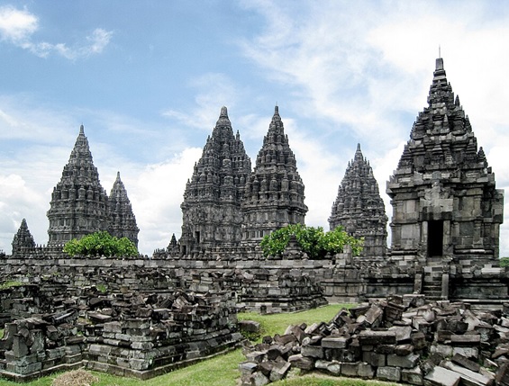
India and Southeast Asia share deep historical and cultural linkages rooted in ancient trade, religion, and cultural exchanges, particularly the spread of Hinduism and Buddhism.
Indonesia, despite being a Muslim-majority nation today, retains strong imprints of Indic civilisation, visible in its temples, art, and traditions.
In recent years, India has emphasised cultural diplomacy through initiatives like Act East Policy, aiming to strengthen ties with ASEAN countries.
The restoration of Prambanan Temple reflects:
FAQs1. Where is Prambanan Temple located ? It is located in Yogyakarta, on the island of Java in Indonesia. 2. Which dynasty built the temple ? It was built by the Sanjaya dynasty in the 9th century. 3. To whom is the temple dedicated ? It is dedicated to the Hindu Trimurti—Brahma, Vishnu, and Shiva. 4. Why is Prambanan Temple significant ? It is the largest Hindu temple complex in Indonesia and a UNESCO World Heritage Site. 5. What is the significance of India–Indonesia collaboration ? It strengthens cultural ties, promotes heritage conservation, and enhances diplomatic relations. |
| Prelims: (Science & Technology + CA) Mains: (GS 3 – Science & Technology, Environment, Energy Security) |
The National Institute of Ocean Technology (NIOT) has successfully tested an indigenously developed Floating LiDAR Buoy System off the coast of Muttom.
This marks a significant step in enhancing India’s capabilities in offshore wind energy assessment and ocean observation technologies.

India is rapidly expanding its focus on renewable energy, including offshore wind power, to meet its clean energy targets.
However, offshore wind development requires accurate, long-term wind data over the sea, which is difficult to obtain due to:
To address these challenges, institutions like the National Institute of Ocean Technology have developed advanced ocean-based instruments such as the Floating LiDAR Buoy System.
The Floating LiDAR Buoy System is a high-tech ocean instrument used to measure atmospheric and wind conditions over the sea.
Principle
The system is based on Light Detection and Ranging (LiDAR) technology.
Mechanism:
Unique Capability
FAQs1. What is a Floating LiDAR Buoy System ? It is an ocean-based system that uses laser technology to measure wind and atmospheric conditions over the sea. 2. Which organisation developed it in India ? The National Institute of Ocean Technology (NIOT). 3. What is LiDAR technology ? It is a remote sensing method using laser pulses to measure distances and atmospheric conditions. 4. Why is it important for offshore wind energy ? It provides accurate wind data, essential for planning and installing offshore wind farms. 5. How does it help in disaster management ? It improves weather forecasting and cyclone tracking, aiding early warning systems. |

Our support team will be happy to assist you!


 Contact Us
  New Batch : 9555124124/ 7428085757
  Tech Support : 9555124124/ 7428085757


