- UPSC Exam
- State PCS
- One Day Exam
- Current Affairs
- PT Quiz
- Downlaods
- About Coaching
- Blog
- Videos
|
Syllabus: Prelims GS Paper I : Current Events of National and International Importance; General issues on Environmental ecology, Biodiversity and Climate Change - that do not require subject specialization. Mains GS Paper III : Disaster and Disaster Management. |
Context
Several tea plantation workers in Idukki district died due to land slide in the State of Kerala.
Background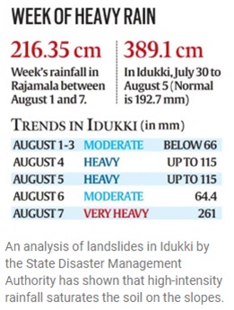
The landslide swept into a settlement housing workers on a tea plantation in Idukki district late Thursday, when most residents were sleeping. Dozens of houses were destroyed and 11 injured people were taken to local hospitals.
The death toll steadily rose as search and rescue workers spent the weekend digging through thick mud and debris, with efforts hampered further by heavy rain. At least 25 people remain missing, more than 500 personnel from local forces and the National Disaster Response Force have been deployed to sift through the debris.
The Indian Meteorological Department issued a warning of "heavy to very heavy rainfall" in certain parts of the state for the next 24 hours.
Vulnerabilities
Kerala has been battered by rain and flooding for weeks. On 7th August, 2020, tragedy struck again when an Air India Express plane skidded off the runway and broke into two while landing at Kozhikode Calicut International Airport amid heavy rain.
For centuries, agriculture in South Asia has depended on the annual monsoon, which stretches from about June until September. But intense rains and floods also cause devastation and billions of dollars in damage and economic loss across much of the region every year.
In 2018, Kerala was hit with its worst flooding in almost a century following unusually high rainfall. Flash floods swept through the state, rivers overflowed and sewage lines were blocked, with more than 300 people killed and hundreds of thousands displaced.
Last year, Kerala and neighboring states were inundated again, with at least 150 killed, hundreds of homes destroyed and hundreds of thousands of people forced to take refuge in relief camps.
|
IDUKKI WILDLIFE SANCTUARY Vegetation Idukki wildlife Sanctuary has numerous tropical and deciduous forests, grasslands. Tropical evergreen forests, meadows, tropical semi-evergreen forests and leaf shedding forestsare the forest types included in the sanctuary. Some of the usually seen trees in the region include Kuntherekkapine, white pine, Pali, Vayana, Cheeni, Bhadraksham, rosewood and meadows of rolling grass. Wildlife The animals found here are elephants, bison, sambar deer, wild dogs, jungle cats, tiger, wild boar, Giant Squirrel etc. We also can see the various species of snakes including cobra, viper, kraits and numerous non-poisonous ones in the Sanctuary. Birds like jungle fowl, Malabar grey hornbill, Black bulbul, Peafowl, Wood pecker, Jungle babbler, small green barbet, large wood shrike, purple sun bird, golden oriole are also the major attraction of the Sanctuary. |
Reasons of Landslides
Natural
Within this the Western Ghats scarps facing west (characterized by thin soil cover and modified heavily by anthropogenic activity) is most vulnerable to landslides. Here, landslides occur mostly as debris/ earth slides or debris flow (‘urul pottal’ in Malayalam), triggered by rainfall during both southwest and northeast monsoons.
The soil has a high content of sand, which absorbs more water, takes a loose form, and is at risk of slipping down. high-intensity rainfall saturates the soil on the slopes. Soil with higher clay content has high water retention capacity and low drainage capacity, leading to high water pressure in the slope material.
Human Induced
Some of these landslides occurred due to cutting the toe of the hill for road construction or due to bank erosion by river, which resulted in near vertical slopes with no provision of lateral support. There are also a few incidences where the location data of the debris flows were collected at runoff areas or at the area of deposition/ accumulation, due to inaccessibility of the source areas.
Most of the disasters (across India) are caused due to cut slope failures, These were of shallow failures along the road wherein the steeply cut slope faces have failed, and also debris flows resulting due to torrent stream conditions in the dissected hill slopes.
These are invariably associated with cut slopes along settlements or roads, or torrent stream along nala (drain) or even channelised debris/earth flow due to very high rainfall.
The post-disaster landslide assessment carried out by GSI (from June 28 to July 7, 2018) revealed that a total of 59 landslide events were recorded in Kozhikode, Idukki, Malappuram, Wayanad, Palakkad and Kannur.
It was observed that 86 percent of the landslides coincided with zones marked as moderate and highly susceptible as per the NSLM map.
Essential Measures to be adopted
The GSI recommends that all cut slopes be properly managed and retaining walls should be made mandatory along road cuts.
The cut slope has to be treated and stabilized and the drainage has to be maintained. We have to look at more critically how to manage the drainage water.
Things to be considered include how much slope is really needed for plantation and on which type of slope we should not plant and if you are planting on slopes then drainage is the most important factor to consider. Drainage management is crucial. If the emphasis is given on draining the water then the cut slope will not fail.
The susceptibility maps can be used to understand what type of landslide size is expect in a specific area and how it behaves in the area and then can be interpret these maps logically in terms of settlement, in terms of any infrastructure. This will help to prioritize resource management, prioritize awareness programmes in villages and prioritize resources at the regional level. Moreover, for disaster preparedness, the run-out distance of the landslide is also significant.
Way Forward
Land use zoning regulation (incorporating landslide susceptibility data) should be made mandatory. It is time to look into land use policies and land management systems in terms of susceptibility and we should also understand that the climate is behaving differently. High rainfall is not very uncommon these days. Zoning is the term used for designating permitted uses of certain parcels of land by local governments.
Awareness is equally important. In cases of casualties in remote areas accessibility is a challenge. So awareness generation is important to lessen the impacts of such disasters.
Connecting the Article
Question for Prelims
Which among the following fauna, is not found in Idukki Wildlife Sanctuary?
(a) Asiatic Lion
(b) Giant Squirrel
(c) Langur
(d) Wild Boar
Question for Mains
In the State of Kerala, due to heavy floods every year landslides kill many people. What could be the measures to curb this disaster?


Our support team will be happy to assist you!

 Contact Us
  New Batch : 9555124124/ 7428085757
  Tech Support : 9555124124/ 7428085757