New
Hindi Medium: (Delhi) - GS Foundation (P+M) : 6th July 2026, 6:00 PM Hindi Medium: (Prayagraj) - GS Foundation (P+M) : 5th July 2026, 8:00 AM English Medium: (Delhi) - GS Foundation (P+M) : 20th July 2026 English Medium: (Prayagraj) - GS Foundation (P+M) : 15th July 2026, 8:00 AM Hindi Medium: (Delhi) - GS Foundation (P+M) : 6th July 2026, 6:00 PM Hindi Medium: (Prayagraj) - GS Foundation (P+M) : 5th July 2026, 8:00 AM English Medium: (Delhi) - GS Foundation (P+M) : 20th July 2026 English Medium: (Prayagraj) - GS Foundation (P+M) : 15th July 2026, 8:00 AM

Western Ghats Landslides Highlight the Need for a Robust Landslide Early Warning System in India

UPSC Prelims

Geography, Environment & Ecology, Disaster Management, Climate Change, Remote Sensing & GIS, Current Affairs.

UPSC Mains

GS Paper III : Disaster Management, Environment, Climate Change, Science & Technology, Internal Security & Disaster Resilience, Infrastructure and Sustainable Development.

Why in News?

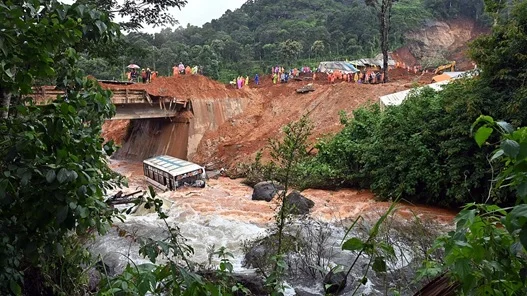
  • Recent landslides in the Western Ghats, including the one affecting the under-construction twin tunnel project in Wayanad, Kerala, have once again highlighted the urgent need for a Landslide Early Warning System (LEWS) in India.
  • Experts believe that scientific forecasting, real-time monitoring, and timely evacuation can significantly reduce casualties and damage in highly vulnerable regions such as the Himalayas and the Western Ghats.

What is a Landslide Early Warning System (LEWS) ?

  • A Landslide Early Warning System (LEWS) is a scientific mechanism that monitors landslide-prone areas, predicts the likelihood of slope failure, and issues timely alerts to authorities and communities, enabling evacuation before a disaster occurs.

Why Does India Need a Landslide Early Warning System ?

  • Landslides are largely predictable in identified high-risk zones.
  • Early warnings help save lives through timely evacuation.
  • They reduce damage to infrastructure, transportation networks, and public property.
  • They enable disaster management agencies to shift from reactive relief to proactive risk reduction.
  • With climate change increasing extreme rainfall events, the frequency and intensity of landslides are expected to rise.

Successful Examples

  • Switzerland has effectively minimized casualties through advanced landslide forecasting and evacuation systems.
  • In Munnar, Kerala (2024), scientific warnings enabled authorities to evacuate residents before landslides occurred, preventing fatalities.

India's Landslide Vulnerability

  • According to the National Disaster Management Authority (NDMA):
  • Around 13% of India's geographical area (about 0.42 million sq. km) is vulnerable to landslides.
  • The Himalayan region and the Western Ghats are the country's most landslide-prone zones.

Highly Vulnerable Regions

  • Tehri Garhwal and Uttarkashi (Uttarakhand)
  • Mandi and Shimla (Himachal Pradesh)
  • Aizawl region (Mizoram)
  • Several parts of Manipur

Comparatively Less Vulnerable

  • Although Sikkim frequently experiences landslides, its overall vulnerability is relatively lower due to:
  • Limited road expansion
  • Reduced mountain cutting
  • Better slope stability

Major Approaches to Landslide Forecasting

1. Sensor-Based Monitoring System

  • Developed by institutions such as Amrita University, this approach involves installing scientific instruments on highly vulnerable slopes.

Key Instruments

  • Tilt meters
  • Pressure gauges
  • Accelerometers
  • Ground movement sensors
  • Vibration sensors

How It Works

  • The sensors continuously monitor changes in slope stability. If any parameter crosses a predefined safety threshold, an automatic warning is sent to local authorities, allowing evacuation before slope failure occurs.

Advantages

  • Highly accurate and scientifically reliable
  • Provides sufficient lead time for evacuation
  • Successfully tested in Kerala

Limitations

  • Monitors only the instrumented slope
  • Cannot predict failures on nearby unmonitored slopes
  • Installation and maintenance are expensive

2. Probabilistic Forecasting Model

  • Developed by IIT Mandi, this model estimates landslide probability over large geographical regions.

Methodology 

  • The model integrates :
    • Historical landslide inventory from satellite data
    • Local rainfall forecasts
    • Soil characteristics
    • Rock stability
    • Slope gradient
    • Population density
    • Seven to ten rainfall-related parameters for every location

Validation

  • The model has been successfully validated against nearly 80 actual landslides in the Himalayan region.

Advantages

  • Covers large geographical areas
  • Identifies multiple vulnerable locations simultaneously
  • Suitable for remote and inaccessible regions

Limitations

  • Depends heavily on high-resolution rainfall forecasts
  • Current rainfall predictions are generally available only one day in advance
  • Improved forecasting by the India Meteorological Department (IMD) would significantly enhance its performance

Towards a National Landslide Early Warning System

  • Experts believe that India can establish a comprehensive nationwide Landslide Early Warning System (LEWS) within the next two years with adequate institutional support and investment.

Key Priorities

  • Identify high-frequency landslide hotspots.
  • Prepare detailed hazard zonation and risk maps.
  • Install sensor networks in the most vulnerable locations.
  • Integrate satellite monitoring with ground-based observations.
  • Use GIS, Remote Sensing, and Artificial Intelligence (AI).
  • Improve high-resolution weather forecasting.
  • Strengthen coordination among NDMA, IMD, Geological Survey of India (GSI), State Disaster Management Authorities (SDMAs), and local administrations.

Challenges

  • Lack of comprehensive mapping of landslide-prone hotspots.
  • Limited deployment of sensor networks.
  • Dependence on short-term rainfall forecasts.
  • High installation and maintenance costs.
  • Weak inter-agency coordination.
  • Limited community awareness and preparedness in vulnerable regions.

Way Forward

  • Develop an integrated National Landslide Early Warning System combining sensor-based monitoring and probabilistic forecasting.
  • Expand landslide susceptibility mapping using GIS, Remote Sensing, satellite imagery, and AI.
  • Strengthen IMD's high-resolution rainfall forecasting capability.
  • Prioritize monitoring of critical infrastructure such as highways, tunnels, railways, dams, and densely populated hill settlements.
  • Improve coordination among NDMA, IMD, GSI, SDMAs, and local governments.
  • Conduct regular community awareness programmes, mock drills, and evacuation exercises.

Institutions Involved

Institution

Role

National Disaster Management Authority (NDMA)

National disaster management policy and coordination

India Meteorological Department (IMD)

Weather and rainfall forecasting

Geological Survey of India (GSI)

Landslide hazard mapping and geological assessment

State Disaster Management Authorities (SDMAs)

State-level implementation

Local Administration

Evacuation, public awareness, and emergency response

Prelims Practice Questions

Q. With reference to the Landslide Early Warning System (LEWS) in India, consider the following statements:

  1. Sensor-based monitoring systems continuously monitor slope stability using instruments such as tilt meters and accelerometers.
  2. Probabilistic forecasting models rely only on rainfall forecasts to predict landslides.
  3. Early warning systems primarily aim to facilitate timely evacuation before a landslide occurs.

Which of the statements given above is/are correct?

  1. 1 and 3 only
  2. 2 only
  3. 1, 2 and 3
  4. 3 only

Mains Probable Question

"With climate change increasing the frequency of extreme rainfall events, landslides have emerged as a major disaster risk in India. Discuss the need for a robust Landslide Early Warning System and examine the challenges in implementing it."

FAQs on Landslide Early Warning System (LEWS) in India  

Q1. What is a Landslide Early Warning System (LEWS) ?

Answer : A Landslide Early Warning System (LEWS) is a scientific system that monitors landslide-prone areas, predicts the possibility of slope failure, and provides timely alerts to authorities and communities to enable evacuation and reduce casualties.

Q2. Why is a Landslide Early Warning System important for India ?

Answer : India is highly vulnerable to landslides, particularly in the Himalayas and the Western Ghats. An effective LEWS helps minimize loss of life, protect critical infrastructure, and improve disaster preparedness through timely warnings and evacuations.

Q3. According to the National Disaster Management Authority (NDMA), what percentage of India's landmass is prone to landslides ?

Answer : According to the NDMA, around 13% of India's landmass (approximately 0.42 million square kilometres) is vulnerable to landslides.

Q4. Which regions of India are most susceptible to landslides ?

Answer : The most landslide-prone regions are The Himalayan region ,The Western Ghats ,Parts of Mizoram, Manipur, Uttarakhand, and Himachal Pradesh.

Have any Query?

Our support team will be happy to assist you!

OR