Context
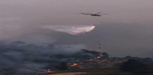
- Arunachal Pradesh and Nagaland have been experiencing severe forest fires for the past week, forcing the Indian Air Force (IAF) to conduct aerial firefighting operations in high-altitude areas.
- These operations are primarily concentrated in the Lohit Valley and Dzukou Valley, where helicopters are dropping thousands of liters of water to protect the sensitive Himalayan ecosystem.
Forest Fires in Northeast India
Fire Pattern
- Fires in the Northeast are primarily surface fires that spread through dry leaves, grass, and forest debris. These fires spread more rapidly up slopes than the crown fires seen in Western countries, especially during the dry winter (December–March).
- The region is a global biodiversity hotspot. Fires pose a serious threat to rare species, local livelihoods, and mountain soil stability.
Key Facts and Figures
- Increasing Fires: In early 2026, fires in Arunachal Pradesh were nearly 200 times more frequent than in the same period in 2025.
- High-Altitude Operations: The Indian Air Force is conducting water-dropping missions above 9,500 feet, which are technically challenging.
- Water Supply: In the Walong area alone, Mi-17 V5 helicopters dropped more than 1.4 lakh liters of water in a week.
- Ecological Sensitivity: The forest cover in the Northeast accounts for approximately 36% of India's total forest cover, making it the country's most sensitive fire hotspot.
- Seasonal Extremes: Nearly 80% of annual fires in the region occur in March–April, but in 2026, this peak occurred untimely in February.
Major Causes of Fire
- Dry Weather and Climate Change: Long dry periods and a lack of adequate winter rainfall (Western Disturbances) dry out the forest floor. Example: In 2026, the lack of moisture in the Lohit Valley made vegetation susceptible to fire.
- Slash-and-Burn/Jhum Cultivation: Traditional farming involves clearing land by setting fires that can spread to forests. Example: Uncontrolled shifting cultivation was identified as the main cause of the Walong fire in Anjaw district.
- Fuel Accumulation: Dry bamboo bushes and pine needles are highly combustible fuels. Example: Dry alpine grass and small rhododendrons in the Dzukou Valley helped the fire spread to Japfu Peak.
- Human Negligence: Negligence by trekkers, hunters, or villagers can cause fires. Example: The recent Dzukou fire required emergency evacuation of 30 trekkers.
- Topographic wind currents: Winds from slopes and valleys push fires rapidly upwards. Example: Strong winds near Japfu Peak helped the fire spread up steep hills.
Steps taken so far
- IAF HADR mission: Precise water drop using Bambi buckets from Mi-17 V5 helicopters
- Coordinated action: Ground operations with the Indian Army's Spear Corps, state forest departments, and local disaster management officials
- FSI monitoring: The Forest Survey of India (FSI) provided real-time fire information through the SNPP-VIIRS system
- Central financial assistance: Support for building fire lines and deploying fire watchers under the Forest Fire Prevention and Management (FPM) scheme
Key challenges
- Inaccessible terrain: Fire trucks are unable to reach many areas due to the inaccessibility of the Himalayas. Example: In Anjaw, ground teams took several days to reach the fire site.
- Thin air and low visibility: Flying helicopters at high altitudes is difficult. Example: IAF pilots in Nagaland had to take water from Padumpokhiri Lake.
- Lack of water sources: Large reservoirs are rare in high-altitude areas. Example: In the Dzukou mission, helicopters had to travel long distances to reach the lakes in Dimapur.
- Communication lag: The time lag between satellite fire information and ground response. Example: By the time the fire information reached remote guards, the fire had already transformed from a surface fire to a more dangerous slope fire.
- Cultural and social factors: Maintaining a balance between traditional farming and forest conservation. Example: Shifting cultivation continues in Arunachal Pradesh because it is linked to tribal culture and food security.
The Way Forward
- Community Fire Fighting Squads: Encouraging local Panchayats to be first responders
- Technology Integration: Drone Night Surveillance and AI-Based Fire Spread Modeling
- Infrastructure Development: Building Permanent Reservoirs in High-Altitude Areas
- Fuel Management: Promoting Commercial Collection of Dry Vegetation (Biofuel)
- Inter-State Coordination: Establishing a Northeast Fire Task Force
Conclusion
The 2026 Northeast forest fires clearly demonstrate that climate-related disasters pose a growing threat to sensitive ecological regions. The swift action by the IAF and Army has been commendable, but the long-term solution lies in striking a balance between traditional practices and modern fire management. Protecting this region is essential for India's climate commitments and regional environmental security.


 Contact Us
  New Batch : 9555124124/ 7428085757
  Tech Support : 9555124124/ 7428085757